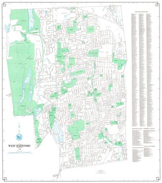
Map Showing Location of Reservoirs and Extent of Watershed for the Hartford Water Works
SurveyorSurveyed by
Seth E. Marsh
(American, about 1823 - 1878)
SurveyorSurveyed by
Henry W. Ayres
(American, 1848 - 1912)
MakerMade for the
Hartford Water Company
(American, founded 1851)
Date1875
MediumDrawing; black ink, blue watercolor, and blue crayon on wove paper on fabric
DimensionsPrimary Dimensions (image height x width): 40 3/4 x 76 3/4in. (103.5 x 194.9cm)
Sheet (height x width): 43 1/2 x 80in. (110.5 x 203.2cm)
ClassificationsGraphics
Credit LineConnecticut Museum of Culture and History collection
Object number1970.27.23
DescriptionMap of parts of Farmington, West Hartford, and Avon, showing the locations of Reservoirs No. 1, 2, 3, and 5. Dyke Pond, Trout Brook, Mine Brook, Long's Pond, and other streams and ponds are shown. Existing and proposed canals connecting the reservoirs are shown. Roads include the Albany Turnpike (present day Route 44) with toll house, Mountain Spring Road, Farmington Road (Farmington Avenue), Middle Road, and South Road. Names of property owners are given. Elevation is indicated with hachure marks. A four-point compass rose is at upper right.
Label TextYou can actually see the Hartford reservoir system taking shape in this 1875 map. Reservoirs No. 1, 2, 3, and 5 are depicted, with Reservoir 2 shown as "proposed." However, these numbers, the numbers by which these reservoirs are still known today, have been penciled in, and the original numbers, written in black ink, have been crossed out. Before this renumbering, Reservoir No. 2 was Reservoir No. 3, Reservoir 3 was Reservoir No. 4, and Reservoir No. 5 was Reservoir No. 2. The decision to create a new reservoir in Farmington, to be known as Reservoir No. 4, must led to this change in numbering. This map also reflects changing conventions in mapmaking. In this map, engineer Seth E. Marsh and his assistant Henry W. Ayres used hachure marks to indicate elevation. A year later, the same two engineers would employ contour intervals to show elevation. This innovation allowed the actual heights of the hills and the steepness of the slopes to be portrayed more accurately.
NotesCartographic Note: One inche equals 400 feetStatus
Not on view