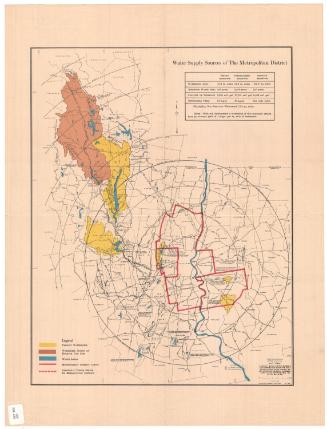
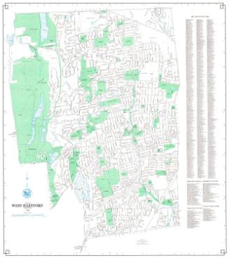
Watershed of Nepaug Reservoir
MakerPrepared for the
Board of Water Commissioners, City of Hartford
(American, founded 1853)
Date1920
MediumBlueprint; cyanotype, graphite, and red ink on wove paper
DimensionsPrimary Dimensions (image height x width): 55 x 45in. (139.7 x 114.3cm)
Sheet (height x width): 61 1/2 x 55in. (156.2 x 139.7cm)
ClassificationsGraphics
Credit LineConnecticut Museum of Culture and History collection
Object number1970.27.19
DescriptionMap of portions of Litchfield County and Hartford County, showing the watershed of the Nepaug Reservoir. Tracks of the New York, New Haven and Hartford Railroad are at the right. The East Brank Reservoir and Greenwood Pond are at the upper right. The Nepaug Reservoir, Nepaug Dam, Phelps Brook Dam, and East Dike are at the lower right. Roads are shown but not identified. Names of property owners are indicated in pencil and red ink. Some names are crossed out.
Label TextAs the population of Hartford grew, the city began to look farther afield in its search for water. The Nepaug Reservoir in Collinsville was begun in 1911 and completed in 1917. The watershed of the reservoir included thirty square miles of privately owned lands, much of it farmland. In 1920, the Board of Water Commissioners expressed concern that some of these farms included "objectionable barnyards" that needed to be cleaned up in order to avoid polluting the reservoir. It seems likely that this 1920 map showing property owners within the Nepaug watershed was connected with this clean-up effort.
NotesCartographic Note: 1 inch equals 1000 feetStatus
Not on view