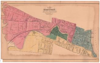
Map of the Second Ward, Hartford, Connecticut
MakerMade by the
Hartford Water Company
(American, founded 1851)
Date1866
MediumDrawings; black, blue, and red ink on wove paper on fabric
DimensionsPrimary Dimensions (image height x width): 45 3/4 x 69 3/4in. (116.2 x 177.2cm)
Sheet (height x width): 47 x 71 1/2in. (119.4 x 181.6cm)
ClassificationsGraphics
Credit LineConnecticut Museum of Culture and History collection
Object number1970.27.2
DescriptionMap of a part of the city of Hartford with Collins Street and Church Street to the north, Main Street to the east, and the Park River to the south and west. Water mains, shown in blue, run along Main Street, a portion of Mill Street, Mulberry Street, Wells Street, Hicks Street, Pearl Street, Asylum Street, Pratt Street, Trumbull Street, Ann Street, High Street, Myrtle Street, Spruce Street, and a portion of Farmington Avenue. The Reservoir, the Deaf and Dumb Asylum, and the railroad station with its associated buildings and tracks are shown. Five bridges, one of them apparently a foot bridge, cross the Park River. The locations of hydrants and stop cocks are indicated.
Label TextAs Hartford grew, new sources of water were needed. Early Hartford drew its water from the Connecticut River, the Park River, and individual wells. In 1854, the newly established Hartford Water Company built a reservoir on Lord's Hill to supplement water drawn from the Connecticut River and individual wells. This 1866 map shows the reservoir and its connectiing water pipes. By this time, the system had already become obsolete, and plans were already under way for the first of a series of reservoirs to be built in West Hattford
NotesCartographic Note: One inch equals 125 feetStatus
Not on view


O.H. Bailey and Company