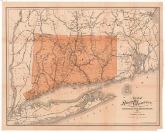
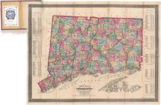
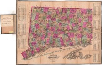
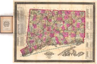
Map of the Railroads of Connecticut, to Accompany the Report of the Railroad Commissioners
MakerPrepared by
Samuel D. Tilden
(American, 1828 - 1893)
PrintmakerLithographed by
Bingham & Dodd
(1860 - 1878)
DistributorDistributed by
William E. Baker
(American, 1830 - 1909)
Date1878
MediumLithography; black and brown printer's inks on wove paper, in card stock covers
DimensionsPrimary Dimensions (image height x width): 20 7/8 x 26 3/4in. (53 x 67.9cm)
Sheet (height x width): 21 3/4 x 27 1/4in. (55.2 x 69.2cm)
Sheet (height x width): 21 3/4 x 27 1/4in. (55.2 x 69.2cm)
ClassificationsGraphics
Credit LineGift of Mrs. J. Coolidge Hills
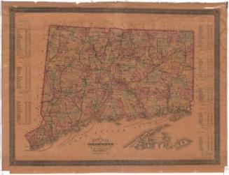
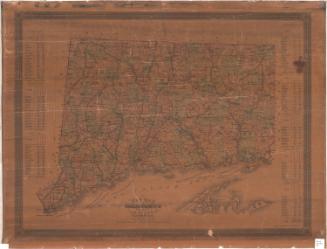
DescriptionMap of the state of Connecticut, with part of Massachusetts to the north, Rhode Island to the east, Long Island and the Long Island Sound to the south, and part of New York to the west. The state is divided into counties, which are delineated with lines and labeled. The main focus of the map is railroad lines in Connecticut, which include the Western; Housatonic; Ridgefield and New York; Naugatuck; Danbury and Norwalk; Shepaug; New York, New Haven and Hartford; New Haven and Northampton; Boston and New York Air Line; Hartford, Providence and Fishkill; Connecticut Central; New London Northern; and the Norwich and Worcester. Some of the routes are marked in broken solid lines and some in solid lines.
Object number1933.37.1
NotesCartographic Note: Scale: 1 inch equals 6 milesOn View
Not on view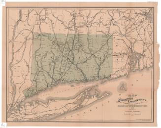


Kellogg & Bulkeley
1910-1915