Interstate 95 Thames River bridges and approaches, New London to Groton
MakerTopggraphy by
James W. Sewell Company
(American, founded 1880)
ProducerProduced by
Connecticut State Highway Department
(American, 1895 - 1969)
Date1964
MediumBlueprints; cyanotype on wove paper
DimensionsPrimary Dimensions (image height x width): 35 x 68 3/4in. (88.9 x 174.6cm)
Sheet (height x width): 36 1/2 x 70 3/4in. (92.7 x 179.7cm)
Sheet (height x width): 36 1/2 x 70 3/4in. (92.7 x 179.7cm)
ClassificationsGraphics
DescriptionMap of portions of Groton and New London, Connecticut, the Thames River, and New London Harbor. Streets and buildings are shown with names and natures of businesses and commercial structures. The United States Coast Guard Academy and the Winthrop Urban Renewal Area are identified. The locations of "historic sites" (Greek revival house) are indicated. Elevation is indicated by contour intervals. Existing Gold Star Memorial Bridge and railroad bridge are shown. Preliminary desgins for new highway bridge and entrance and exit ramps are superimposed on map.
Object number1965.97.0
NotesCartographic Note: 1: 2,400On View
Not on view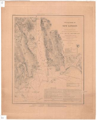

Underwood & Underwood
c. 1920-1940