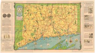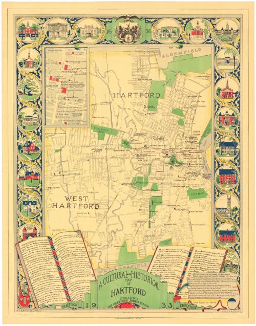
A Cultural and Historical Map of Hartford
DesignerDesigned by
Katherine C. Bartholomew
(American, 1907 - 1992)
DesignerDesigned by
Dorothey G. Spalding
(American, 1906 - 1985)
PrinterPrinted by
Kellogg & Bulkeley
(American, 1867 - 1990)
PublisherDedicated to the
Hartford Junior League
(American, founded 1914)
Date1933
MediumLithography; colored printer's inks on pale yellow wove paper
DimensionsPrimary Dimensions (image height x width): 26 3/4 x 21in. (67.9 x 53.3cm)
Sheet (height x width): 28 x 22in. (71.1 x 55.9cm)
Sheet (height x width): 28 x 22in. (71.1 x 55.9cm)
ClassificationsGraphics
Credit LineConnecticut Museum of Culture and History collection
DescriptionMap of Hartford and West Hartford, Connecticut, with Bloomfield to the north and Wethersfield to the south. Locations of historic sites, parks, and schools are shown. Images of open books below the map list important buildings in Hartford and famous Hartford residents. A scroll lists additional sites of interest, including many relating to Native Americans in Hartford. A decorative scrollwork border is illustrated with images of the Soldiers and Sailors Memorial Arch, the Harriet Beecher Stowe House, the Mark Twain House, the Charles Dudley Warner House, the Lydia Sigourney House, the Charter Oak, the Old North Church, the Old State House, the Municipal Building, the Wadsworth Atheneum, the Morgan Memorial, the Bushnell Memorial, the State Capitol, the State Library, Center Church, the Children's Museum, the McCook House, the Henry Barnard House, Trinity College Chapel, the Noah Webster House, and the Elizabeth Park Rose Gardens. The seal of the city of Hartford is at the top. A lyre and an artist's palette are at the bottom.
Object number2005.199.0
NotesCartographic Note: No scaleOn View
Not on view