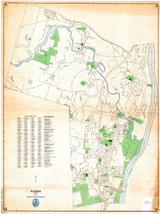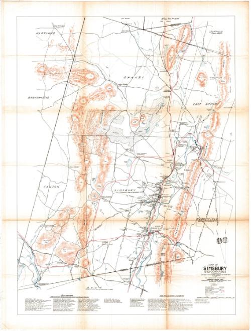
Map of Simsbury, Conn. 1642-1935
DraftsmanDrawn by
William Floyd Hamilton
(American, 1903 - 1994)
Date1935
MediumLithography; colored printer's inks on wove paper
DimensionsPrimary Dimensions (image height x width): 30 x 22in. (76.2 x 55.9cm)
Sheet (height x width): 35 x 25in. (88.9 x 63.5cm)
ClassificationsGraphics
Credit LineGift of William C. Conklin
Object number1971.71.15
DescriptionMap of Simsbury with Hartland, Granby, East Granby, Suffield, and Southwick, Massachusetts to the north; Bloomfield (Wintonbury) to the east; Avon to the south; and Canton and Barkhamsted to the west. Rivers, brooks, and ponds are shown and named. Hills and mountains are shown and named and elevation is indicated by hachure marks. Modern and early roads and Indian trails are shown. The Connecticut Western Railroad is shown with its date. The route of the Farmington Canal is indicated by a broken blue line. Old boundary lines are shown and dated. Other features include the First and Second Fairgrounds, the McLean Game Refuge, the probable location of the Great Fort. A key gives the location of old houses with the names of the builders, dates, and names of current (1935) owners. A second key lists other places of interest. A compass at lower right indicates the direction of true north and magnetic north. A scale of feet and miles is at lower right.
Label TextLike many other Connecticut towns, Simsbury took an active part in the celebration of the state Tercentenary in 1935. The celebration in Simsbury included a costume ball, a school pageant, an exhibition of antiques, weekly teas, and a band concert with a speech by Gifford Pinchot. A replica of Simsbury's first meeting house was produced for the celebration. Monuments were erected to mark historic sites. Publications included a short history of Simsbury--and this map, drawn by William Floyd Hamilton, chief engineer at Ensign Bickford. The map superimposes historic features on a modern map of Simsbury and manages to convey a remarkable amount of information with considerable clarity.
NotesCartographic Note: One inch equals one half mileStatus
Not on view