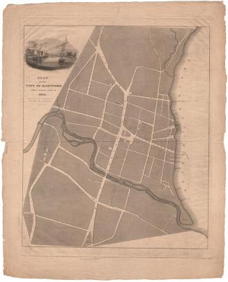
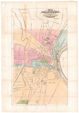
Elihu Geer's New Map of Hartford from the latest surveys
PublisherPublished by
Elihu Geer
(American, 1817 - 1887)
PrinterPrinted by
Elihu Geer
(American, 1817 - 1887)
Date1882
MediumLithography; black printer's ink and watercolor on wove paper, in cardboard covers
DimensionsPrimary Dimensions (image height x width): 18 3/8 x 10in. (46.7 x 25.4cm)
Sheet (height x width): 20 x 12 1/4in. (50.8 x 31.1cm)
ClassificationsGraphics
Credit LineConnecticut Museum of Culture and History collection
Object number1989.172.0
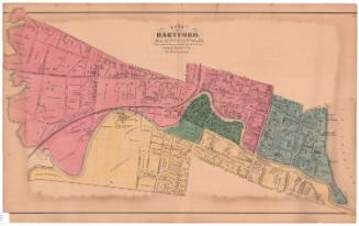
DescriptionMap of part of Hartford, Connecticut, from the town line of Bloomfield to the north, the Connecticut River to the east, the town line of Wethersfield to the south, and the town line of West Hartford to the west. The city is divided into eight wards, colored blue, pink or yellow, with the locations of each ward's voting place denoted with the number of the ward.
Bushnell Park and four cemeteries are colored green. There are concentric circles at 1/2 mile intervals from Union Station. The roads are labeled. The Hartford and New Haven; Hartford, Providence and Fishkill; Connecticut Western; and Connecticut Valley Railroads run through town. Physical features include the Connecticut and Park Rivers, and Meadow Creek. A pamphlet accompanying the map contains information about the streets of Hartford, including their location on the map and whether they had sewage and gas infrastructure and whether they were paved or curbed.
Bushnell Park and four cemeteries are colored green. There are concentric circles at 1/2 mile intervals from Union Station. The roads are labeled. The Hartford and New Haven; Hartford, Providence and Fishkill; Connecticut Western; and Connecticut Valley Railroads run through town. Physical features include the Connecticut and Park Rivers, and Meadow Creek. A pamphlet accompanying the map contains information about the streets of Hartford, including their location on the map and whether they had sewage and gas infrastructure and whether they were paved or curbed.
Label TextThroughout most of the nineteenth century, Elihu Geer published the Hartford city directory. City directories were similar to a latter day telephone books. They included names and addresses of people and businesses plus miscellaneous information about the city and a wealth of advertisements. From the beginning these directories always included maps which became larger and more elaborate as time went on. In 1882, Geer's directory include "a new map of the city, from surveys made for Mr. Geer, showing all the new streets." Obsolete street names were listed together with the current names. Although typically Geer's maps were an integral part of his directories, this copy of the 1882 map, which folds into cardboard covers stamped with Geer's name, was evidently issued separated.
NotesCartographic Note: Scale: 1 inch equals 1500 feetStatus
Not on view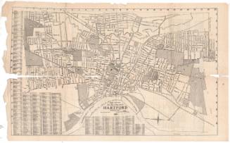


Kellogg & Bulkeley
1910-1915
Kellogg & Bulkeley
1915-1920