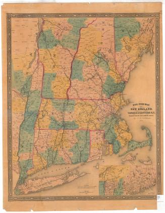
New Hampshire
PublisherPublished by
Joseph Hutchins Colton
(American, 1800 - 1893)
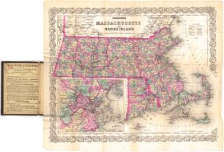
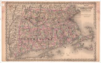
Date1855
MediumLIthography; black printer's ink and watercolor on wove paper, in cardboard covers
DimensionsPrimary Dimensions (image height x width): 15 3/4 x 12 1/4in. (40 x 31.1cm)
Sheet (height x width): 16 7/8 x 13 5/8in. (42.9 x 34.6cm)
ClassificationsGraphics
Credit LineGift of Mrs. Francis T. Maxwell
Object number1928.10.2
DescriptionPocket map of the state of New Hampshire, with part of Maine to the east, part of Massachusetts to the south, and part of Vermont to the west. The state is divided into counties, colored pink, blue, yellow, or peach, and is outlined in pink. The Portland Branch of the Grand Trunk; Vermont Central; Montreal; White Mountain; Concord and Claremont; Cheshire; Porsmouth and Concord; Boston and Maine; Nashua and Wilton; and Manchester and Lawrence Railroad lines are all shown. Local roads are depicted too, but are not labeled. Physical features include elevation, conveyed through hachure marks; rivers; and lakes.
Label TextNorthern New England was linked to Connecticut by the Connecticut River, which forms the boundary between New Hampshire and Vermont. Even though the river is not navigable north of Hartford, its valley forms a natural transportation corridor. In the nineteenth century, the railroads provided an additional connection between northern and southern New England and travelers moved easily back and forth for business and for pleasure. The White Mountains of New Hampshire was already a popular tourist destination by the middle of the nineteenth century.
NotesCartographic Note: 3/4 inch equals 10 milesStatus
Not on view