Woodland Trails near Bristol
MakerData by
Romeyn A. Spare
(American, 1885 - 1968)
PublisherPublished by
Connecticut Forest and Park Association
(American, founded 1895)
DraftsmanDrawn by
Perry N. Deming
(American, 1888 - 1962)
Date1933
MediumBlueprint; cyanotype on wove paper
DimensionsPrimary Dimensions (image height x width): 21 1/2 x 15in. (54.6 x 38.1cm)
Sheet (height x width): 22 x 15 1/2in. (55.9 x 39.4cm)
ClassificationsGraphics
Credit LineGift of Gary W. Potter
Object number2012.548.3
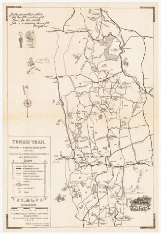
DescriptionMap of the Tunxis Trail system in Bristol, Connecticut, and the surrounding communities of Collinsville, Canton, Unionville, Farmington, Burlington, Harwinton, Plantsville, Plymouth, Terryville, and Wolcott. Parts of the Mattatuck, Metacomet, and Qunnipiac Trails are also shown. Major features include the Nepaug Reservoir, Buttermilk Falls and other waterfalls, a fish hatchery, a coppermine, a log cabin, a quarry, an unconformity, the Devil's Kitchen, the Johnnycake Mountain Fire Tower, and Tories Den. Major state highways include Routes 10, 6, 177, 167, 101, and 117. Small cartoon figures include hikers, rock climbers, a man cooking over a campfire, and a woman wading in a pond.
Label TextThe Connecticut Forest and Park Association began laying out hiking trails in 1929, and by 1933, when this map of the Tunixis Trail was published, the blue trail system in Connecticut was already quite extensive. The Tunxis Trail, located conveniently close to Hartford, was one of the first trails to be completed. Romeyn Spare and Perry Deming, the two men who collaborated on this map in 1933, produced an updated version in 1955, almost twenty years later..
NotesCartographic Note: One inch equals one mileStatus
Not on view