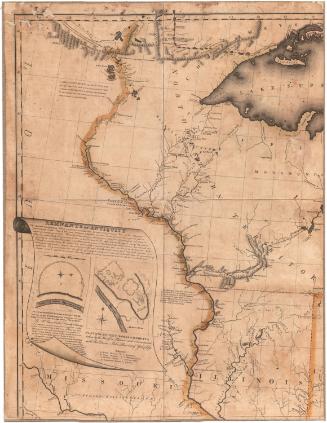
Vermont from Actual Survey
DraftsmanDrawn by
Amos Doolittle
(American, 1754 - 1832)
PrintmakerEngraved by
Amos Doolittle
(American, 1754 - 1832)
Date1795 or later
MediumEngraving; black printer's ink and watercolor on wove paper, in cardboard covers
DimensionsPrimary Dimensions (image height x width): 14 7/8 x 11 5/8in. (37.8 x 29.5cm)
Platemark (height x width): 15 1/4 x 12in. (38.7 x 30.5cm)
Sheet (height x width): 15 3/8 x 12 5/8in. (39.1 x 32.1cm)
ClassificationsGraphics
Credit LineMuseum purchase
Object number1912.7.0
DescriptionMap of Vermont, with Canada to the north, New Hampshire to the east, Massachusetts to the south, and New York to the west. Vermont is divided primarily into counties, each outlined in red, yellow or green. Town divisions and names are also shown. Dartmouth is located along the Connecticut River in Windsor County. Physical features depicted include elevation, conveyed with clusters of peaks; rivers; and lakes, including Lake Champlain. Roads are shown but not labeled. Waterfalls and tall trees adorn the cartouche.
Label TextThe first large-scale map of the state of the Vermont was engraved by Amos Doolittle and based on surveys by Vermont's surveyor general, James Whitelaw. The New Haven, Connecticut engraver got the job because there was no engraver in Vermont at that time capable of such fine work. This reduced version of Doolittle's great map was issued as a folding pocket map. Similar to modern road maps, pocket maps were readily portable, but needed to be unfolded in order to be consulted and used. Folding and unfolding increased the risk of tears, and pocket maps are rarely found in good condition. The hand-coloring in this pocket map appears to be original.
NotesCartographic Note: Scale: About 1/2 inch equals 5 milesStatus
Not on view