
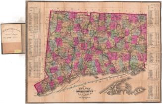
New Map of Connecticut
PublisherPublished by
Samuel D. Tilden
(American, 1828 - 1893)
PrinterPrinted by
Bingham & Dodd
(1860 - 1878)
Date1875
MediumLithography; printer's ink and watercolor on wove paper
DimensionsPrimary Dimensions (image height x width): 20 3/4 x 27 1/4 x 22 3/4 x 29 3/4in. (52.7 x 69.2 x 57.8 x 75.6cm)
ClassificationsGraphics
Credit LineGift of J. Coolidge Hills
Object number1909.6.1
DescriptionMap of Connecticut, from Massachusetts to the north, Rhode Island to the east, part of Long Island and the Long Island Sound to the south, and New York to the west. The state is divided into counties and towns, outlined and colored pink, green, or yellow. Natural features include lakes, rivers and islands, and roads are depicted. Railroad lines shown on the map include Portchester and Ridgefield; New York, New Haven and Hartford; Housatonic; Boston, Hartford and Erie; Connecticut Valley; Boston and New York Air Line; New London Northern; Connecticut Western; and Shore Line Railroads. On the left and right sides of the map are population tables for towns in each of the counties
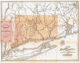
Label TextThere is nothing very "new" about the appearance of Samuel D. Tilden's New Map of Connecticut. It is closely based on a map that Baker & Tilden had published ten years earlier, and it follows the traditional format of still earlier maps. However, it apparently enjoyed some popularity, since it was reissued several times in the 1870s and 1880s. This 1875 edition must have been published early in the year, since Thomaston still appears as part of Plymouth and it was incorporated as a separate town in 1875.
NotesCartographic Note: One inch equals four and a half milesStatus
Not on view


Kellogg & Bulkeley
1910-1915