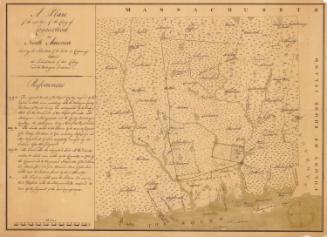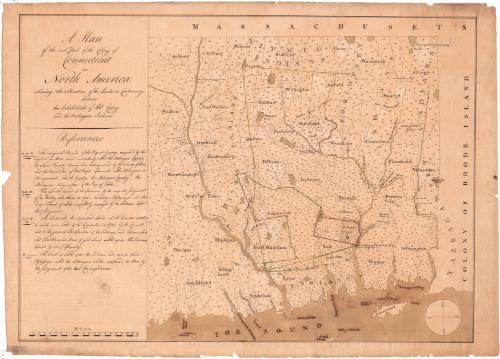
A Plan of the East Part of the Colony of Connecticut
DraftsmanDrawn by
Unknown
Date1766-1771
MediumDrawing; ink on laid paper
DimensionsPrimary Dimensions (image height x width): 20 1/8 x 28in. (51.1 x 71.1cm)
Sheet (height x width): 21 7/8 x 30 1/8in. (55.6 x 76.5cm)
ClassificationsGraphics
Credit LineGift of the Johnson Family
Object number1913.9.3
DescriptionMap of eastern Connecticut with Suffield, Windsor, Weathersfield, Middle Town, Haddam, Durham, and Guildford on the west, Massachusetts to the north, the Colony of Rhode Island to the east, and The Sound to the South. The land is densely dotted with what appear to be small houses. References at the left provide a key to "the Original Bounds of the Pequot Country conquered by the English in 1638, since mistakenly called the Moheagan Country," "Lands decreed to the Indians by the ex parte judgment of Jos. Dudley and others in 1703," "the Tract called the sequestered Land, all disputes relative to which were settled by the Committee in 1721," and "the Tract so settled upon the Indians and now in their Possession called the Moheagan Fields confirmed to them by the judgment of the last Commissioners." A scale of miles is at the lower left. A simple compass indicating north, south, east, and west is at the lower right.
Label TextIn 1766, William Samuel Johnson was appointed Connecticut's colonial agent in London and was charged with defending Connecticut's claim to Mohegan lands in southeastern Connecticut. The Mohegans had been contesting Connecticut's right to these lands since the early 1700s. Recent decisions had gone against them, and in 1770, the Mohegans appealed to the Privy Council. This map is one of three maps showing the contested territory that Johnson presumably had prepared in support of his defense of Connecticut's claims. The Privy Council decided in favor of the Colony of Connecticut and this judgment was later confirmed by the Crown.
NotesCartographic Note: One inch equals three milesConstituent Note: Although the three maps in the Connecticut Historical Society are virtually identical, the handwriting varies dramatically, indicating that it was done by three different people.
Date Note: Johnson was appointed colonial agent in 1766 and it is possible that a prototype of the three maps in the Connecticut Historical Society was prepared at that time. The three existing maps were probably all produced in London during the appeal to the Privy Council in 1770 or 1771.
Status
Not on view