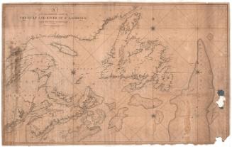
Chart of Long Island Sound
PrintmakerEngraved by
William Hooker
(American, 1782 - 1856)
PublisherPublished by
Edmund and George W. Blunt
(American, 1830 - 1866)
PublisherPublished by
American Coast Pilot
(American, 1796 - 1867)
Date1827
MediumEngraving; printer's ink on wove paper
DimensionsPrimary Dimensions (image height x width): 6 3/4 x 17 1/8in. (17.1 x 43.5cm)
Sheet (height x width): 8 1/2 x 18in. (21.6 x 45.7cm)
Sheet (height x width): 8 1/2 x 18in. (21.6 x 45.7cm)
ClassificationsGraphics
Credit LineMuseum purchase
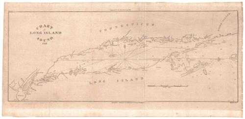
DescriptionChart of Long Island Sound from New York Harbor to the west to Block Island to the east. The Connecticut coast is to the north and the coast of Long Island is to the south. Lighthouses are indicated. A small sailing vessel is depicted on a course between Fisher's Island and Great Gull Island. Soundings are given. Notations provide additonal information such as "This reef sometimes dry" and "Good Fishing Ground." A scale of statute miles is at lower right.
Object number2007.83.0
NotesCartographic Note: One inch equals ten milesOn View
Not on view