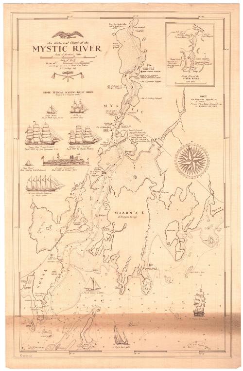
An Historical Chart of the Mystic River
DraftsmanDrawn by
John E. Dodge
(American, 1916 - 1978)
Date1949
MediumLithography; brown printer's ink on laid paper
DimensionsPrimary Dimensions (image height x width): 23 3/8 x 14 7/8in. (59.4 x 37.8cm)
Sheet (height x width): 24 5/8 x 16in. (62.5 x 40.6cm)
ClassificationsGraphics
Credit LineMuseum purchase
Object number1949.19.1
DescriptionChart showing the Mystic River, from the Narrows to the north to Ram Island to the south. Water depth is marked in feet. Many of the physical features of the area are labeled, including coves, points, islands and necks, as are the locations of local sites, such as boat yards, yacht clubs, and the Marine Museum (now Mystic Seaport). Old place names are shown in italics and current (as of 1949) in regular text. Below the title are illustrations of seven ships that were built in Mystic: the sloop "hero," a brig, a clipper ship "David Crockett," the clipper "Twilight," the sloop "Annie," the steamer Connecticut, and a five-master schooner. Three other ships are depicted in the chart image area: a Noank smack, a Mystic-built yacht and a Mystic whaleship. In the top right is an inset map of the upper River, from Old Mystic to the north to Mystic in the south.
Label TextHistorical maps are quite common, but historical charts are quite uncommon. Perhaps this is at least in part because even more than maps, most charts are intended for a practical purpose, for use in navigation, and physical features such as the location of sandbars and the depth of the water are subject to change over time. This historical chart of the Mystic River emphasizes the importance of local shipbuilding and depicts a number of the vessels associated with the area. The Maritime Museum, located at the site of the Greenman Shipyard, would later be known as Mystic Seaport.
NotesCartographic Note: Scale: 3/4 inch equals 1/8 mileConstituent Note: J. E. Dodge also produced an historical chart of Stonington Harbor, 1649-1949.
Status
Not on view


Lieutenant William Augustus Wetmore
1887-1895

Artvue Post Card Co.
1900-1950