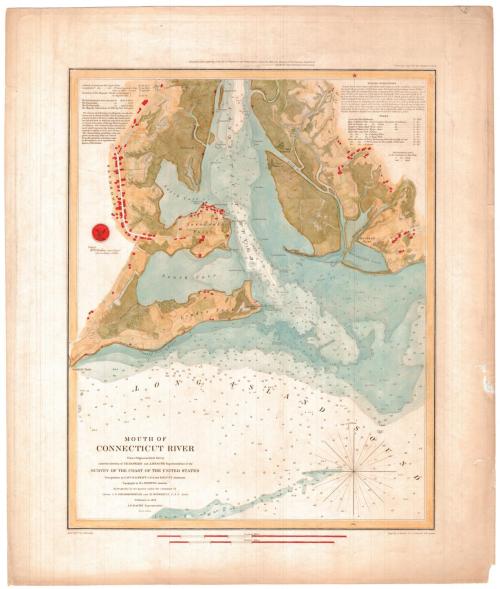
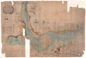
Mouth of Connecticut River
PublisherPublished by the
United States Coast Survey
(American, founded 1807)
MakerTopography by
Henry L. Whiting
(American, 1821 - 1897)
SurveyorTriangulation by
William Harrison Swift
(American)
SurveyorTriangulation by
Edmund March Blunt
(1770 - 1862)
MakerHydropgraphy under the direction of
John R. Goldsborough
(American, 1809 - 1877)
MakerHydrography under the direction of
Maxwell Woodhull
(American, 1813 - 1863)
MakerMagnetic observations by
James Renwick
(American, 1792 - 1863)
PrintmakerElectrotyped by
George Mathiot
(American, died 1873)
SurveyorUnder the direction of
Alexander Dallas Bache
(American, 1806 - 1867)
SurveyorUnder the direction of
Ferdinand Rudolph Hassler
(American, 1770 - 1843)
Date1853
MediumElectrotype; black printer's ink and watercolor on wove paper
DimensionsPrimary Dimensions (image height x width): 17 3/8 x 14in. (44.1 x 35.6cm)
Platemark (width only): 17 3/4in. (45.1cm)
Sheet (height x width): 21 3/4 x 18 3/8in. (55.2 x 46.7cm)
ClassificationsGraphics
Credit LineMuseum purchase
Object number1981.146.0
DescriptionChart of the mouth of the Connecticut River where it meets the Long Island Sound, with Lyme Creek to the north, Griswold's Cove to the east, the Long Island Sound to the south, and South and North Coves to the west. Water depth is marked first in feet to 18 feet and then in fathoms, and is also hand-colored in shades of blue to reflect depth. The surrounding land is also shown, with lines and symbols used to indicate different types of land. These are also hand-colored in shades of green and yellow. Along the roads, clusters of black squares indicate the presence of buildings, and these areas are colored red. To the top left of the chart is information about the latitude and longitude, the courses, bearings, and soundings. To the top right are sailing directions and tide information.
Label TextThe earliest known chart ot the mouth of the Connecticut River, was made by John Copp in 1720. This was followed by Captain Abner Parker's Chart of Saybrook Bar, published in 1771. The United States Coast Sruvey carried out surveys of the area in 1835, 1845, 1849, 1850, and 1851. The results of these surveys are summarized in this 1853 chart, which shows the three channels that existed at that time. The low-lying sandy islands and sandbars at the river's mouth continue to shift and change over time.
NotesCartographic Note: Scale: 1:20,000Status
Not on view

Object/Object