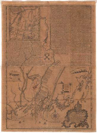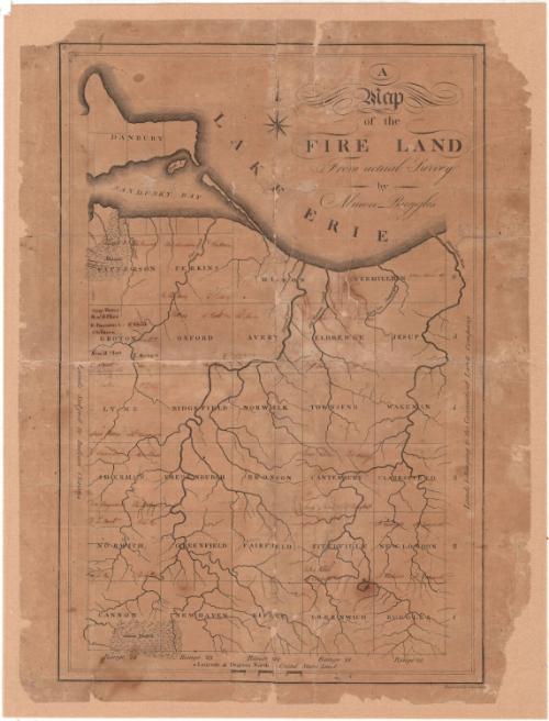
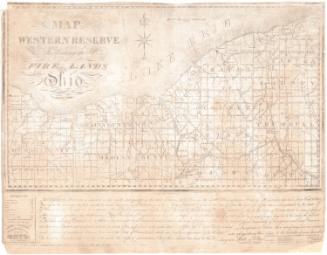
A Map of the Fire Land from actual Survey
SurveyorSurveyed by
Almon Ruggles
(American, 1771 - 1840)
PrintmakerEngraved by
Amos Doolittle
(American, 1754 - 1832)
Date1806?
MediumEngraving; black printer's ink on paper, lined with paper
DimensionsPrimary Dimensions (image height x width): 18 x 12in. (45.7 x 30.5cm)
Sheet (height x width): 19 1/8 x 14 3/8in. (48.6 x 36.5cm)
Mount (height x width): 20 x 15 1/4in. (50.8 x 38.7cm)
Sheet (height x width): 19 1/8 x 14 3/8in. (48.6 x 36.5cm)
Mount (height x width): 20 x 15 1/4in. (50.8 x 38.7cm)
ClassificationsGraphics
Credit LineConnecticut Museum of Culture and History collection
DescriptionMap of the Firelands in Ohio, with Lake Erie and Sandusky Bay to the north, the Vermillion River and Connecticut Land Company land to the east, and "lands subject to Indian claim" to the west. The townships of Danbury, Patterson, Perkins, Huron, Vermillion, Groton, Oxford, Avery, Eldredge, Jesup, Lyme, Ridgefield, Norwalk, Townsend, Wakeman, Sherman, Vredenburgh, Bronson, Canterbury, Clarksfield, Norwich, Greenfield, Fairfield, Fitchville, New London, Cannon, New Haven, Ripley, Greenwich, and Ruggles are all shown. Physical features depicted include rivers, the lake and bay, and marshes. Range numbers are shown along the right and bottom sides of the image.
Object number1990.182.0
NotesCartographic Note: No scaleOn View
Not on view

Nathan Ruggles
Nathan Ruggles