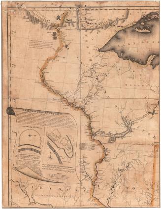
A Map of the Fire Land from actual Survey
SurveyorSurveyed by
Almon Ruggles
(American, 1771 - 1840)
PrintmakerEngraved by
Amos Doolittle
(American, 1754 - 1832)
Date1806?
MediumEngraving; black printer's ink on paper, lined with paper
DimensionsPrimary Dimensions (image height x width): 18 x 12in. (45.7 x 30.5cm)
Sheet (height x width): 19 1/8 x 14 3/8in. (48.6 x 36.5cm)
Mount (height x width): 20 x 15 1/4in. (50.8 x 38.7cm)
ClassificationsGraphics
Credit LineConnecticut Museum of Culture and History collection
Object number1990.182.0
DescriptionMap of the Firelands in Ohio, with Lake Erie and Sandusky Bay to the north, the Vermillion River and Connecticut Land Company land to the east, and "lands subject to Indian claim" to the west. The townships of Danbury, Patterson, Perkins, Huron, Vermillion, Groton, Oxford, Avery, Eldredge, Jesup, Lyme, Ridgefield, Norwalk, Townsend, Wakeman, Sherman, Vredenburgh, Bronson, Canterbury, Clarksfield, Norwich, Greenfield, Fairfield, Fitchville, New London, Cannon, New Haven, Ripley, Greenwich, and Ruggles are all shown. Physical features depicted include rivers, the lake and bay, and marshes. Range numbers are shown along the right and bottom sides of the image.
Label TextIn 1805, Almon Ruggles left Danbury, Connecticut to survey the so-called Firelands. This portion of the Western Reserve, which was also known as the "Sufferers' Lands," was to be given as compensation to residents of Connecticut towns that were burned by the British during the American Revolution. In addition to Danbury, the towns included Fairfield, Greenwich, Groton, New Haven, New London, Norwalk, and Ridgefield. Ruggles remained in the future state of Ohio after completing his survey and enjoyed a successful career as a state legislator and judge. Ruggles township, which appears on this map, was named for him.
NotesCartographic Note: No scaleStatus
Not on view


Nathan Ruggles

Nathan Ruggles