Map of the World from the best Authorities
PrintmakerEngraved by
Amos Doolittle
(American, 1754 - 1832)
PublisherPublished by
Thomas & Andrews
(American, active 1793 - 1814)
Date1796
MediumEngraving; black printer's ink on laid paper
DimensionsPrimary Dimensions (image height x width): 7 1/8 x 14in. (18.1 x 35.6cm)
Platemark (height x width): 7 7/8 x 14 5/8in. (20 x 37.1cm)
Sheet (height x width): 9 1/8 x 18 3/8in. (23.2 x 46.7cm)
ClassificationsGraphics
Credit LineConnecticut Museum of Culture and History collection
Object number2005.196.0
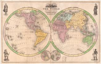
DescriptionMap of the world, with the western hemisphere on the left and the eastern hemisphere on the right. All of the continents except for Antarctica are depicted, and many countries are named but not demarcated. Lines of latitude and longitude are marked every ten degrees, and the Antarctic Circle, Tropic of Capricorn, Tropic of Cancer, and the Arctic Circle are also shown. The only physical features shown on the map are rivers, of which only major rivers are named.
Label TextJedidiah Morse was born in Woodstock, Connecticut in 1761. He attended Yale College, and spent the next few years teaching and preaching in Connecticut, Massachusetts, and Georgia, finally settling as a pastor in Charlestown, Massachusetts. Seeing the need for a good geography textbook, Morse published Geography Made Easy in 1784, followed by The American Geography in 1789, Elements of Geography in 1795, and the American Gazeteer in 1797. This map appeared in Morse's Universal Geography. These many publications earned Morse the title of "Father of American Geography." He was the father of the inventor Samuel F. B. Morse.
NotesCartographic Note: No scaleStatus
Not on view