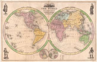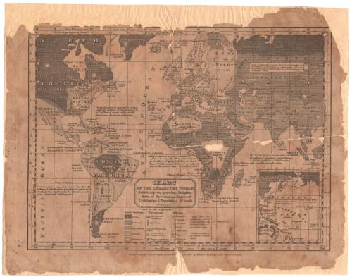
Chart of the Inhabited World
MakerCompiled by
William C. Woodbridge
(American, 1794 - 1854)
Date1821
MediumEngraving; black printer's ink on laid paper, mounted on paper
DimensionsPrimary Dimensions (image height x width): 8 5/8 x 11 3/4in. (21.9 x 29.8cm)
Platemark (width only): 12 1/2in. (31.8cm)
Sheet (height x width): 10 1/8 x 13 1/8in. (25.7 x 33.3cm)
Mount (height x width): 10 1/2 x 13 3/8in. (26.7 x 34cm)
Platemark (width only): 12 1/2in. (31.8cm)
Sheet (height x width): 10 1/8 x 13 1/8in. (25.7 x 33.3cm)
Mount (height x width): 10 1/2 x 13 3/8in. (26.7 x 34cm)
ClassificationsGraphics
Credit LineConnecticut Museum of Culture and History collection
DescriptionMap of the world (excluding Antarctica), using different line styles to indicate the "state of civilization" ("savage," "barbarous," "half-civilized," "civilized," and "enlightened"). The type of government (monarchy/imperial, republican, limited monarchy, independent chiefs or dukes, and viceroys or governors under another country), religion (Christian, Catholic, Protestant, Greek, "Mahometan," and "pagan"), and the locations of missionary stations are depicted using symbols. In text next to each country or region is information about its population and physical size. An inset map in the lower right corner shows the Pacific islands.
Object number2005.195.0
NotesCartographic Note: Scale: No scaleOn View
Not on view