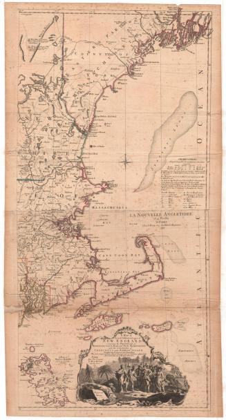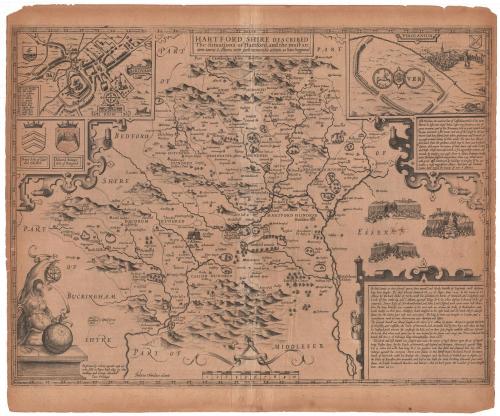
Hartfordshire Described
DraftsmanDrawn by
John Speed
(English, 1552 - 1629)
PrintmakerEngraved by
Jodocus Hondius
(Flemish, 1563 - 1612)
Date1605-1610
MediumEngraving; black printer's ink on laid paper
DimensionsPrimary Dimensions (image height x width): 15 1/8 x 20 1/8in. (38.4 x 51.1cm)
Platemark (height x width): 15 3/8 x 20 3/8in. (39.1 x 51.8cm)
Sheet (height x width): 17 1/4 x 20 1/2in. (43.8 x 52.1cm)
ClassificationsGraphics
Credit LineConnecticut Museum of Culture and History collection
Object number2005.194.0
DescriptionMap of Hertfordshire, England, depicting the landscape and historic events. Circles and other symbols (none of which are explained) show the locations of what were presumably buildings, dwellings and estates. In the top left corner is an inset map of "Hartforde," depicting the ancient town. Below it are two shields, one belonging to Roger de Clare, Earl of Hertford, and the other to Edward Seinour (Seymour), Earl of Hertford. In the top right corner there is another inset map of Verulanium (an ancient Roman British town), showing a walled field and, in the distance, a small city. In the bottom left corner is a a female figure holding a sphere with a cartographers' tools and another sphere, possibly a globe, resting on the table in front of her. In the bottom right corner is a textual description of Hertfordshire county and its historic battles.
On the back of the map, which was originally in a book, is a list of the different parts of Hertfordshire (named on the map), and the places that appeared within them. On the right side of the page is a textual description of Hertfordshire.
On the back of the map, which was originally in a book, is a list of the different parts of Hertfordshire (named on the map), and the places that appeared within them. On the right side of the page is a textual description of Hertfordshire.
Label TextThis map from John Speed's famous atlas of Great Britain shows the county of Hertfordshire and its county seat, Hertford as they appeared in the early seventeenth century. Speed spelled the names of the county and city "Hartfordshire" and "Hartford" and this spelling would be perpetuated in the name of Hartford, Connecticut, which was founded in 1635. One of Hartford's early settlers, Samuel Stone, came from Hertford.
NotesCartographic Note: Scale: There is a scale marker in the center bottom of the map, but no indication of the units used.Date Note: The original engraving dates from the early 17th century, although the paper this map was printed on is suspect as it is acidic, which is not generally a quality of 17th century paper.
Related Note: Three items accompanied the map: two copies of a letter detailing the map's acquisition and relevance to Hartford, Connecticut; and a small photograph depicting a man standing in front of a monument in Parliament Square, Hertford, England with buildings in the background. (Lee 7/8/2013)
Status
Not on view
James Liddell Goldie
1927