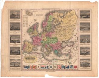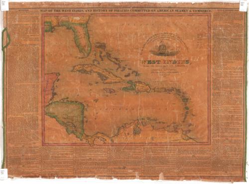
Map of the West Indies and History of Piracies Committed on American Seamen and Commerce
PrintmakerEngraved by
N. & S. S. Jocelyn
(American, founded 1818)
PrinterPrinted by
Sidnet Converse
(American, 1790 - 1873)
PublisherPublished by
Monson and Co.
(American, active1825 - 1827)
Date1825
MediumEngraving; black printer's ink and water color on wove paper, lined with linen
DimensionsPrimary Dimensions (image height x width): 19 5/8 x 27 3/8in. (49.8 x 69.5cm)
Sheet (height x width): 20 5/8 x 27 3/4in. (52.4 x 70.5cm)
Mount (height x width): 20 5/8 x 28 1/8in. (52.4 x 71.4cm)
ClassificationsGraphics
Credit LineConnecticut Museum of Culture and History collection
Object number1963.99.0
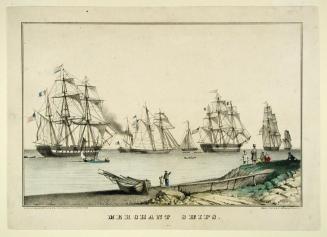
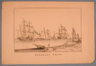
DescriptionMap of the Caribbean, with Florida to the north and the coasts of Central and South America to the south. The countries are colored according to what country they belonged to: England, France, Spain, the Netherlands, Denmark or Sweden. Physical features include elevation, conveyed through hachure marks, and rivers. The cartouche depicts several sailing vessels. Outside the map image area are an account of Commodore Porter's "affair at Foxardo" in 1824, a list of piracies committed on American vessels from 1818 to 1825, and an account of the death of Lieutenant Allen at the hands of pirates.
Label TextMany Connecticut residents engaged in trade with the West Indies during the early nineteenth century. As shown in this 1825 map published in New Haven, piracy continued to be a serious problem in this period. Two incidents involving the United States Navy are singled out for special notice. In 1822, Lieutenant William Howard Allen of the U.S.S. Alligator was killed in battle with three pirate vessels. Then in 1824, while suppressing piracy, Commodore David Porter invaded the small town of Fajardo (or Foxardo) to avenge the jailing of an officer from his fleet. Porter was court-martialed and suspended from the service, but this map implies that he was simply doing his duty.
NotesCartographic Note: Scale: about 7/8 inch equals 100 milesStatus
Not on view