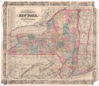
Map of New-York
MakerCopyrighted by
Sidney E. Morse
(American, 1794 - 1871)
PrinterPrinted by
Sidney Babcock
(American, 1797 - 1888)
PublisherPublished by
N. & S. S. Jocelyn
(American, founded 1818)
Date1828
MediumEngraving; black printer's ink and watercolor on wove paper
DimensionsPrimary Dimensions (image height x width): 11 7/8 x 14 1/2in. (30.2 x 36.8cm)
Sheet (height x width): 13 1/8 x 15 1/4in. (33.3 x 38.7cm)
ClassificationsGraphics
Credit LineConnecticut Museum of Culture and History collection
Object number1960.140.0
DescriptionMap of the state of New York, with Upper Canada to the north; Vermont, Massachusetts and Connecticut to the east; Pennsylvania and New Jersey to the south; and Lake Erie to the west. The state is divided into counties, with the locations of towns and cities appearing as numbered circles that corresponds with the index that appears around the sides of the map. There is an inset of the Greater New York City area. Physical features depicted include elevation, conveyed with hachure marks; rivers; and lakes.
Label TextSidney E. Morse was the son of the well-known geographer, Jedidiah Morse, and the brother of the well-known inventor Samuel F. B. Morse. Sidney Morse collaborated with his father on several atlases which were published in New Haven, Connecticut, and this map of New York State probably comes from one of these. New Haven was an important center of printing and publishing at the beginning of the nineteenth century, but it was gradually eclipsed by Hartford and then by other publishing centers such as Philadelphia and New York City.
NotesCartographic Note: Scale: 1 inch equals about 45 milesStatus
Not on view