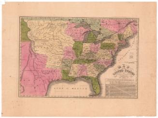
An Improved Map of the United States
DraftsmanDrawn by
Shelton & Kensett
(American, founded 1813)
PrintmakerEngraved by
Amos Doolittle
(American, 1754 - 1832)
PublisherPublished by
Shelton & Kensett
(American, founded 1813)
Date1813
MediumEngraving; black printer's ink and watercolor on laid paper
DimensionsPrimary Dimensions (image height x width): 17 5/8 x 19 1/2in. (44.8 x 49.5cm)
Platemark (height x width): 19 3/8 x 22in. (49.2 x 55.9cm)
Sheet (height x width): 20 1/8 x 24 5/8in. (51.1 x 62.5cm)
ClassificationsGraphics
Credit LineGift of Mrs. C. G. Rockwood
Object number1917.13.1
DescriptionMap of the United States, depicting East and West Florida, Georgia, South Carolina, North Carolina, Tennessee, Kentucky, Ohio, Virginia, Maryland, Pennsylvania, Delaware, New Jersey, New York, Connecticut, Rhode Island, Massachusetts, Vermont, New Hampshire, and the District of Maine. Orleans Territory, Mississippi Territory, Illinois Territory, Indiana Territory, Northwest Territory, and Louisiana are also shown, along with Upper and Lower Canada, Nova Scotia, and New Brunswick. Towns are marked with circles. Physical features include elevation, conveyed through clusters of peaks, rivers, islands, and lakes. In the Atlantic Ocean part of the map, several ships are depicted with descriptions of how they fared in battle in 1812 and 1813: the U.S. Frigate Chesapeak; the U.S. Frigate Constitution; the U.S. Sloop of War Wasp; the U.S. Sloop of War Hornet; the U.S. Sloop of War Argus; and the U.S. Frigate United States. Distance lists appear on both sides of the map, and below it are lists of the inhabitants and staple commodities of each state. The cartouche depicts an eagle with outstretched wings perched above the U.S. shield.
Label TextCreated in the midst of the War of 1812, this map records the major naval battles of that conflict. It was an early publication of the firm of Shelton & Kensett, located in the little rural town of Cheshire, Connecticut. Shelton & Kensett also published Ralph Rawdon's engraving of the Battle Fought Near Moravian Town October 2nd 1813 and Let the Weapons of War Perish, designed by Thomas Kensett himself, and many other maps and prints. Kensett was the father of the well-known landscape painter John Frederick Kensett.
NotesCartographic Note: Scale: about 1/2 inch equals 50 miles; 69 1/2 miles to 1 degreeStatus
Not on view
George W. Corliss


2000 May 10