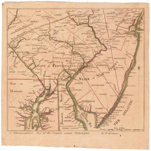
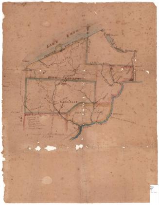
A Chorographical Map of the Country round Philadelphia
DraftsmanDrawn by
Bernard Romans
(American, 1741 - 1784)
Date1778
MediumEngraving; black printer's ink and watercolor on laid paper
DimensionsPrimary Dimensions (image height x width): 11 5/8 x 13in. (29.5 x 33cm)
Platemark (height only): 12 1/2in. (31.8cm)
Sheet (height x width): 13 3/4 x 14in. (34.9 x 35.6cm)
ClassificationsGraphics
Credit LineConnecticut Museum of Culture and History collection
Object number1991.192.0
DescriptionMap of the region near Philadelphia, Pennsylvania, showing the counties of Lancaster, Berks, North, Hampton, Bucks, Philadelphia, Chester and York in Pennsylvania; Salem, Cumberland, Gloucester, Burlington, Monmouth, Middlesex, Morris, Essex and Berge Counties in New Jersey; and New Castle and Kent Counties in Delaware. Part of Maryland is depicted in the lower left corner. The Grand American Winter Camp of January 1778 is shown in Valley Forge, Pennsylvania. Towns are marked with circles, and churches and what are probably town halls or courthouses are noted with small buildings. Physical features include bays, rivers and elevation, conveyed with clusters of peaks.
Label TextA "chorographical" map is a map of a region, something between a town and an entire country. The term was already on its way to becoming obsolete when Bernard Romans used it in the title of this map of the Philadelphia area. Published in June 1778, it shows the site of Washington's "Grand American Winter Camp" at Valley Forge the previous winter. Romans, a Dutch engineer in the service of the British when the Revolution broke out, quickly shifted his allegiance to the American cause. He was responsible for some of the most important early maps of the conflict. In 1779, he married Elizabeth Whiting, of Wethersfield, Connecticut.
NotesCartographic Note: Scale: 1 inch equals about 12 milesStatus
Not on view


Kellogg & Bulkeley
1910-1915