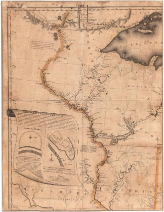
Map of the United States
DraftsmanDrawn by
Laura Giddings
(American, born 1814)
Date1826 or 1827
MediumDrawing; black ink on wove paper
DimensionsPrimary Dimensions (image height x width): 15 5/8 x 25 1/2in. (39.7 x 64.8cm)
Sheet (height x width): 19 1/4 x 27in. (48.9 x 68.6cm)
ClassificationsGraphics
Credit LineMuseum purchase
Object number1993.172.0
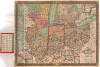
DescriptionManuscript map of the United States, with labels denoting the states of Florida, Georgia, Alabama, Mississippi, Tennessee, Kentucky, North Carolina, Virginia, Illinois, Indiana, Ohio, Pennsylvania, and New York; and the Arkansas Territory, Northwest Territory, and Missouri Territory. The New England states, Delaware, New Jersey and Maryland are not labeled. Upper and Lower Canada and part of present-day Mexico is also shown. Land west of the Missouri Territory and Rocky Mountains is labeled as "Unexplored country." Physical features shown include elevation, conveyed with clusters of small symbols representing mountains; rivers; and lakes. The Rocky Mountains and Coast Range mountains are depicted while the Appalachian Mountains are not.
Label TextThe Danbury Academy and Young Ladies' Seminary offered all the branches of a thorough "English, Mathematical, and Classical education." The copying of maps was one way in which the young ladies were taught geography. Laura Giddings's map, which she drew in the late1820s, is evidently incomplete, leaving many blank spaces in the East as well as in the still unexplored West. Laura apparently based her map on John Melish's 1816 Map of the United States with the contiguous British & Spanish Possessions. Like Melish's map, it includes a river in California "which will probably be the connection between the Atlantic and the Pacific."
NotesCartographic Note: No scaleStatus
Not on view

Samuel Augustus Mitchell
1834

Samuel Augustus Mitchell
1835