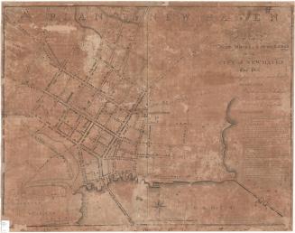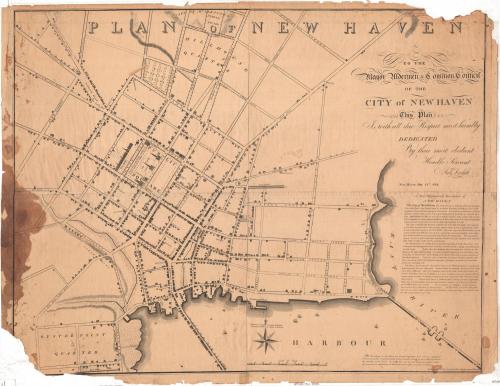
Plan of New Haven
SurveyorSurveyed by
Amos Doolittle
(American, 1754 - 1832)
PrintmakerEngraved by
Amos Doolittle
(American, 1754 - 1832)
PublisherPublished by
Amos Doolittle
(American, 1754 - 1832)
Date1824
MediumEngraving; black printer's ink on wove paper
DimensionsPrimary Dimensions (image height x width): 28 3/8 x 35 1/8in. (72.1 x 89.2cm)
Platemark (width only): 37in. (94cm)
Sheet (height x width): 29 1/2 x 38in. (74.9 x 96.5cm)
ClassificationsGraphics
Credit LineMuseum purchase
Object number1965.96.0
DescriptionMap of the town of New Haven, Connecticut, focusing on the town green and its surrounding blocks, with Temple Square to the north, the East River to the east, the harbor to the south, and Howe Street to the west. In the public square, the State House, Episcopal church, United Society church and Old Burying Ground are shown. Yale College is pictured above College Street. Dwellings and shops are represented with drawings of buildings and are not labeled. Other notable landmarks include the new burying ground, public well, county jail, bell foundry, rope walks, and Tomlinson's Bridge. Boats are depicted in the harbor and along the Union or Long Wharf. On the right side is a written geographical description of the city.
Label TextAmos Doolittle produced the first edition of his Plan of New Haven in 1812. One would have expected that the city would have grown substantially by 1824, when Doolittle issued this new edition, but he appears to have changed little but the date. In the late eighteenth and early nineteenth century, it was not unusual for one individual to play multiple roles in the creation of a map. According to the inscription on this map, Doolittle not only engraved and published it, but also made the survey upon which the map was based.
NotesCartographic Note: Scale: 5/8 inch equals 10 rodsStatus
Not on view