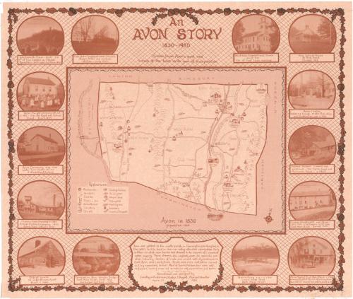
An Avon Story
DesignerDesigned by
Dorothy J. Anderson
(American, 1921 - 1994)
DesignerDesigned by
Gladys T. August
(American, 1921 - 2013)
DesignerDesigned by
Marian M. Hunter
(American, 1917 - 1987)
MakerResearched by
Dorothy J. Anderson
(American, 1921 - 1994)
MakerResearched by
Gladys T. August
(American, 1921 - 2013)
MakerResearched by
Marian M. Hunter
(American, 1917 - 1987)
Date1980
MediumLithography; brown printer's ink on wove paper
DimensionsPrimary Dimensions (image height x width): 22 1/8 x 26in. (56.2 x 66cm)
Sheet (height x width): 23 1/8 x 27 1/8in. (58.7 x 68.9cm)
ClassificationsGraphics
Credit LineGift of the Avon Story Commission
Object number1980.101.0
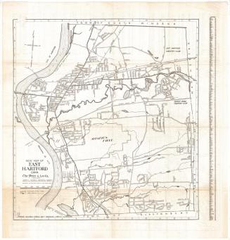
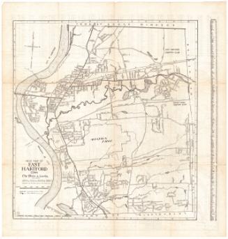
DescriptionMap of the town of Avon in 1830, with Canton and Simsbury to the north, Windsor and Hartford to the east, Farmington to the south, and Burlington and the Farmington River to the west. Different areas of the town are labeled: "Whortleberry Hill," "Lovely Town," East Avon," "West Avon," "Old Farm," "Pine Woods," "Nod Division," "Nod Hill," and "Cider Brook." Drawings are used to show the locations of blacksmiths, grist and sawmills, taverns or inns, schoolhouses, cemeteries, churches, carding machines, turning mills, wagon shops, fulling mills, farming areas, distilleries, and canals and towpaths. Also depicted are the sites of historic events. Fourteen vignettes around the map show the West Avon Congregational Church; Nod School House; Avon Center; the former Holmes sawmill and gristmill; Canal Warehouse and Store; Avon Market; a team of horses and men harvesting ice; the Farmington River Wooden Bridge; the oldest house in Avon; Climax Fuse Company; Avon Creamery; Avon Heights; Wadsworth Tower; and the East Avon Congregational Church. Physical features include elevation, depicted with clusters of peaks, brooks, woods, and rivers.
Label TextAvon was one of seven new towns carved from the territory of the original town of Farmington, once one of the largest towns in the state. Avon's develpment was spurred by the opening of the Farmington Canal in 1829 and it became a separate town in 1830, adopting the name Avon at that time. Previously it was known as Northington or Nod. The map shows the town as it appeared in 1830, and the surrounding images reflect its picturesque, rural character. It was the work of three local women, Dorothy J. Anderson, Gladys T. August, and Marian M. Hunter.
NotesCartographic Note: No scaleStatus
Not on view