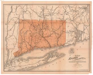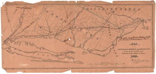
Map of the Central and Direct Land Route from Boston to New York
DraftsmanDrawn by
William P. Parrott
(American, 1810 - 1868)
PrinterPrinted by
Sharp, Pierce & Company
(American, 1846 - 1849)
Date1847
MediumLithography; black printer's ink and watercolor on wove paper
DimensionsPrimary Dimensions (image height x width): 8 1/16 x 18 3/4in. (20.5 x 47.6cm)
Sheet (height x width): 8 7/8 x 19in. (22.5 x 48.3cm)
ClassificationsGraphics
Credit LineGift of Frank F. Starr
Object number1896.10.1
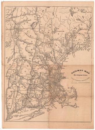
DescriptionMap of Long Island, most of Connecticut minus the northwest corner, and the eastern part of Massachusetts, depicting the railroad route between New York City and Boston. The railroads are not labeled, but show the New York, New Haven and Hartford Railroad and the Air Line. Other railroads include the Western Railroad; the New Haven-Springfield Line of the Hartford and New Haven Railroad; the Stonington Railroad; the Providence Railroad; and the Boston and Worcester Railroad.
Label TextConnecticut's early railroads ran mainly north and south. The obvious east-west route ran along the shoreline, but was interrupted by several major rivers. During the 1840s, the main east-west route ran through southern Massachusetts. Promoters imagining a direct line from New York to Boston were attracted by the so-called airline route, which ran diagonally across the state of Connecticut from New Haven to Boston. The route ran through Middletown, Connecticut, but by-passed Hartford. Not surprisingly, the route's chief supporters were Middletown men, while Hartford businessmen were violently opposed. Although a charter was obtained and extensive surveys were carried out, little actual work was done. The project would be revived in the late 1860s.
NotesCartographic Note: Scale: Almost 1/2 inch equals 5 milesStatus
Not on view