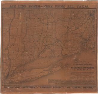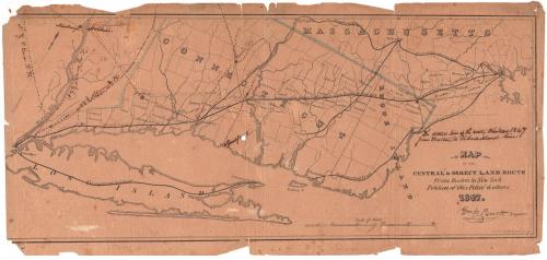
Map of the Central and Direct Land Route from Boston to New York
DraftsmanDrawn by
William P. Parrott
(American, 1810 - 1868)
PrinterPrinted by
Sharp, Pierce & Company
(American, 1846 - 1849)
Date1847
MediumLithography; black printer's ink and watercolor on wove paper
DimensionsPrimary Dimensions (image height x width): 8 1/16 x 18 3/4in. (20.5 x 47.6cm)
Sheet (height x width): 8 7/8 x 19in. (22.5 x 48.3cm)
Sheet (height x width): 8 7/8 x 19in. (22.5 x 48.3cm)
ClassificationsGraphics
Credit LineGift of Frank F. Starr
DescriptionMap of Long Island, most of Connecticut minus the northwest corner, and the eastern part of Massachusetts, depicting the railroad route between New York City and Boston. The railroads are not labeled, but show the New York, New Haven and Hartford Railroad and the Air Line. Other railroads include the Western Railroad; the New Haven-Springfield Line of the Hartford and New Haven Railroad; the Stonington Railroad; the Providence Railroad; and the Boston and Worcester Railroad.
Object number1896.10.1
NotesCartographic Note: Scale: Almost 1/2 inch equals 5 milesOn View
Not on view