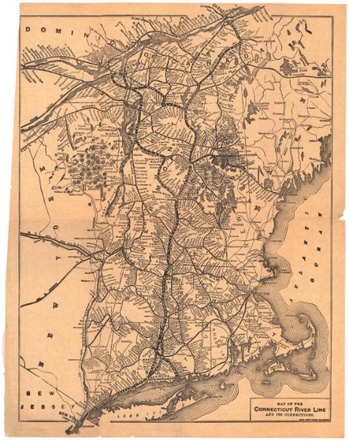
Map of the Connecticut River Line and its Connections
PublisherPublished by
Rand Avery Supply Co.
(American, founded 1871)
Dateafter 1892
MediumLithography; black printer's ink on wove paper
DimensionsPrimary Dimensions (image height x width): 16 7/8 x 12 1/8in. (42.9 x 30.8cm)
Sheet (height x width): 16 7/8 x 13 1/4in. (42.9 x 33.7cm)
Sheet (height x width): 16 7/8 x 13 1/4in. (42.9 x 33.7cm)
ClassificationsGraphics
Credit LineConnecticut Museum of Culture and History collection
DescriptionMap of part of the eastern United States and Canada, depicting parts of Ontario, Quebec, New York, Vermont, Maine, New Hampshire, Massachusetts, Rhode Island and Connecticut. It shows what is referred to as the "Connecticut River Line," which appears to be the various railroad lines that ran north-south along the Connecticut River, including the New York, New Haven and Hartford Railroad; Boston and Maine; Vermont Valley; Connecticut Valley; and Quebec Central Railroads. The connecting routes in the area are also depicted but are not as prominent. They include the New York, New Haven and Hartford; Central New England; New York Central and Hudson River; Maine Central; Rutland; Central Rutland; Canadian Pacific; and Grand Trunk Railroads. The locations of stations along many, but not all, of the lines shown are also depicted. Physical features include elevation, conveyed with hachure marks, rivers, lakes and islands.
Object number2005.192.0
NotesCartographic Note: No scaleOn View
Not on view
Matthews-Northrup Company
1913