The New York, New Haven, and Hartford Railroad Company, Operated and Controlled Lines
PublisherPublished by
Rand Avery Supply Co.
(American, founded 1871)
Dateabout 1900
MediumLithography; black printer's ink on wove paper
DimensionsPrimary Dimensions (image height x width): 8 1/4 x 15 5/8in. (21 x 39.7cm)
Sheet (height x width): 9 x 16in. (22.9 x 40.6cm)
Sheet (height x width): 9 x 16in. (22.9 x 40.6cm)
ClassificationsGraphics
Credit LineConnecticut Museum of Culture and History collection
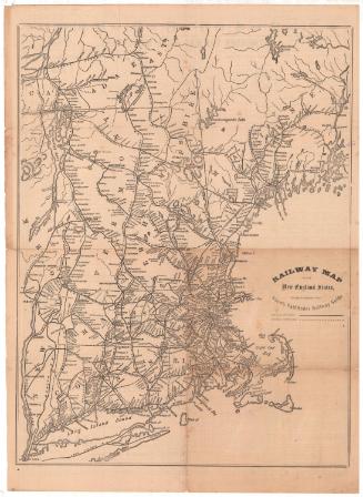
DescriptionMap of Connecticut, Massachusetts, Rhode Island, and the New York City and Hudson River area of New York and New Jersey. The New York, New Haven and Hartford Railroad Company lines are the main focus of the map, with the network extending from New York into Hartford, Providence and Boston, as well as the smaller towns. All of the stops are shown as white circles, and are labeled with the name of the town. Most of the lines themselves are not labeled, with the exception of the Central New England line. The Long Island Sound steamer is marked with a broken solid line. On the back are timetables for routes between points in Connecticut and between Hartford and Springfield, Massachusetts.
Object number2006.139.0
NotesCartographic Note: No scale
Constituent Note: Many companies produced railroad maps, but the Rand Avery Supply Company of Boston specialized in railroad maps and timetables and appears to have produced little else. The firm supported the railroad industry in other ways as well, printing tickets and baggage claim tokens for a number of American and Canadian Railroads.On View
Not on view