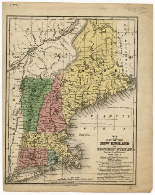
Map of the New England or Eastern States
PrintmakerEngraved by
James H. Young
(American, active 1817 - 1866)
PublisherPublished by
Samuel Augustus Mitchell
(1792 - 1868)
Date1839
MediumEngraving; black printer's ink on wove paper
DimensionsPrimary Dimensions (image height x width): 10 3/8 x 8 1/8in. (26.4 x 20.6cm)
Sheet (height x width): 11 5/8 x 9 1/4in. (29.5 x 23.5cm)
ClassificationsGraphics
Credit LineMuseum purchase
Object number1952.99.0
DescriptionMap of New England, including "Lower Canada" (present-day Quebec), New Brunswick and New York. The New England states are colored pink, green or yellow, and each state is divided into counties, delineated with dotted lines. County towns and capitals are marked on the map. Railroads and canals are shown but are not labeled. Physical features depicted include elevation, conveyed through hachure marks, rivers, lakes, and islands.
Label TextThe engraver James H. Young and the publisher S. Augustus Mitchell worked together on a number of maps and atlases in Philadelphia during the 1830s. At this time, Mitchell was a young man just starting out. Born in Bristol, Connecticut, he was originally a teacher, but moved to Philadelphia and began writing and publishing books on geography because he found existing textbooks inadequate. This map of the New England states appeared in Mitchell's School and Family Geography, a typical early Mitchell publication. Young, who was employed by Mitchell to engrave the maps in these early books, was a much older man, with more than twenty years of experience behind him. In the 1840s, Mitchell would begin using the newer and less expensive technique of lithography to reproduce the maps in his books.
NotesCartographic Note: Scale: 1 inch equals almost 50 milesStatus
Not on view