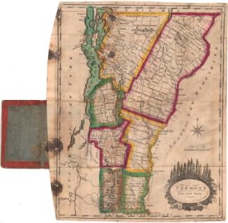
Vermont from Actual Survey
DraftsmanDrawn by
Amos Doolittle
(American, 1754 - 1832)
PrintmakerEngraved by
Amos Doolittle
(American, 1754 - 1832)
PublisherPublished by
Mathew Carey
(American, 1760 - 1839)
Date1795
MediumEngraving; printer's ink on wove paper
DimensionsPrimary Dimensions (image height x width): 14 7/8 x 11 3/4in. (37.8 x 29.8cm)
Platemark (height x width): 15 1/4 x 11 7/8in. (38.7 x 30.2cm)
Sheet (height x width): 17 1/4 x 14 5/8in. (43.8 x 37.1cm)
ClassificationsGraphics
Credit LineMuseum purchase
Object number1911.8.1
DescriptionMap of Vermont with the state of New York to the west, Canada to the north, the state of New Hampshire to the east, and the state of Massachusetts to the south. Town and county boundaries are shown, major rivers and lakes are identified, some roads are shown. Mountains are realistically depicted as ranges of peaks. An eight-point compass rose is at the right, above a scale of miles and and an elaborate cartouche with the text in an oval surmounted by evergreen trees and dense foliage, with a rushing stream at the bottom.
Label TextThe first large-scale map of the state of the Vermont was engraved by Amos Doolittle and based on surveys by Vermont's surveyor general, James Whitelaw. The New Haven, Connecticut engraver got the job because there was no engraver in Vermont at that time capable of such fine work. This reduced version of Doolittle's great map is also an important first; it appeared in Mathew Carey's American edition of Guthrie's Universal Geography, published in Philadelphia in 1795, the first American atlas to be published in America.
NotesCartographic Note: 1 inch = ca. 11 milesStatus
Not on view