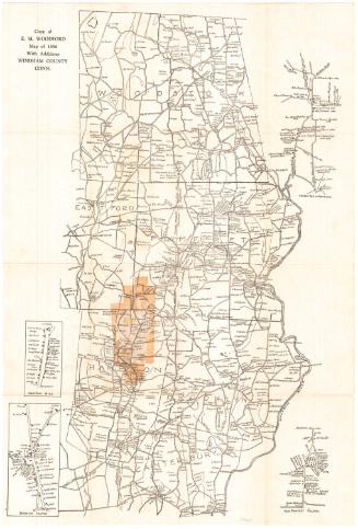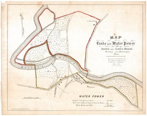
Map of Lands and Water Power for sale by Oliver and James Moore Erving and Montague, Mass.
SurveyorSurveyed by
James Stevens
(American, active 1856)
SurveyorSurveyed by
S. Moore
(American, active 1856)
PrinterPrinted by
E.B. & E.C. Kellogg
(American, 1840 - 1867)
Date1856
MediumLithography; printer's ink and watercolor on wove paper
DimensionsPrimary Dimensions (image height x width): 14 x 17 5/8in. (35.6 x 44.8cm)
Sheet (height x width): 14 3/4 x 18 3/4in. (37.5 x 47.6cm)
ClassificationsGraphics
Credit LineMuseum purchase
Object number1993.171.0
DescriptionMap showing property located near Grout's Corner on Miller's River in Erving and Montague, Massachusetts. The Vermont and Massachusetts Railroad runs through the property; a hotel and a railroad depot are shown on Wendell Road at Grout's Corner. The roads to Greenfield, Northfield, Montague, and Erving are also indicated, as well as a proposed dam and canal, and the houses of M. Grout and J. Moore. Small trees are used to indicate that most of the land is wooded; a meadow is also indicated. A compass showing "True North" and "North by Compass" is at the upper left.
Label TextMartin Grout (1790-1865) established a farm on Miller's River in Franklin County, Massachusetts in 1824. With the arrival of the railroad in th 1850s, this area, with its abundant water power, was perceived as ripe for industrial development. Millers Falls Manufacturing Company would be constructed on the site in 1868 and the tiny community of Grout's Corner would subsequently become known as Miller's Falls. Oliver and James Moore, who commissioned this map in an attempt to sell property here in 1856, may have been related to the Moore family of Berlin, Connecticut.
NotesCartographic Note: 1 inch = 400 feetStatus
Not on view