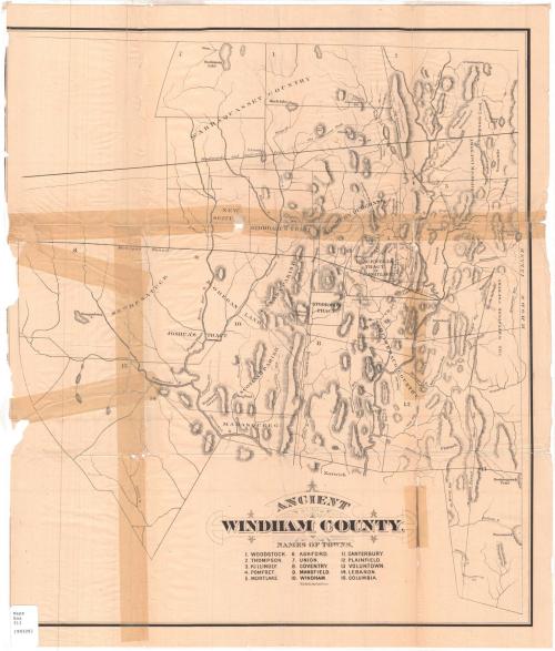
Ancient Windham County
PrinterPrinted by
J. H. Bufford's Sons
(American, 1873 - 1880)
Date1874
MediumLithography; black printer's ink on wove paper
DimensionsPrimary Dimensions (image height x width): 21 3/8 x 18 7/8in. (54.3 x 47.9cm)
Sheet (height x width): 23 x 19 5/8in. (58.4 x 49.8cm)
ClassificationsGraphics
Credit LineConnecticut Museum of Culture and History collection
Object number2006.136.0
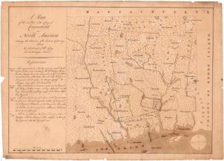
DescriptionHistorical map of Windham County, showing its former boundaries. The state of Rhode Island is to the east; the town of Norwich is to the south. The Massachusetts state line is to the north, but is not identified. Other apparent boundaries include Woodward's and Saffery's line and the "Mohegan Bound." Roads indicated include "The Old Connecticut Path," "The Providence Road," "The Greenwood Path," and the "Nipmunk Path." Other areas identified include the Wabbaquassett Country, Quinebaug Country, Nipmunk Country, the Whetstone Country, and Mohegan Land, as well as Mamasqueeg, Joshua's Tract, New Besatuck, New Scituate, Stoddard's Tract, Canada Parrish, Roxbury Parrish, and Blackwell's Tract. Rivers, including the Willimantic and Shetucket Rivers, ponds, lakes, and hills are also shown. Elevation is indicated by hachure marks.
Label TextA great deal of early history may be gleaned from this map, which was originally prepared to accompany Ellen Larned's 1874 book on the History of Windham County from 1660 to 1760. The map includes areas that would later become part of neighboring Tolland and New London Counties, and shows that a large proportion of Windham County, the area north of Woodward and Saffery's line, was once claimed by Massachusetts. Even south of this line, many early settlers received their land grants from Massachusetts, not Connecticut. Ironically, Larned's book was printed in Worcester, Massachusetts, while the map was printed in Boston, despite the fact that Hartford, Connecticut was a flourishing center of printing and publishing at the time it was produced.
NotesCartographic Note: No scaleSubject Note: This map originally appeared in Ellen D. Larned, History of Windham County, Connecticut, Vol. I (Worcester, Mass.: Published by the author, 1874).
Status
Not on view
J. H. Bufford's Sons