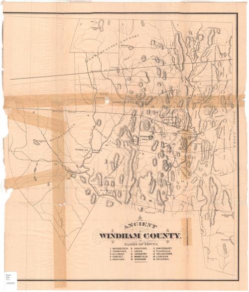
Ancient Windham County
PrinterPrinted by
J. H. Bufford's Sons
(American, 1873 - 1880)
Date1874
MediumLithography; black printer's ink on wove paper
DimensionsPrimary Dimensions (image height x width): 21 3/8 x 18 7/8in. (54.3 x 47.9cm)
Sheet (height x width): 23 x 19 5/8in. (58.4 x 49.8cm)
Sheet (height x width): 23 x 19 5/8in. (58.4 x 49.8cm)
ClassificationsGraphics
Credit LineConnecticut Museum of Culture and History collection
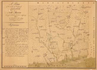
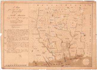
DescriptionHistorical map of Windham County, showing its former boundaries. The state of Rhode Island is to the east; the town of Norwich is to the south. The Massachusetts state line is to the north, but is not identified. Other apparent boundaries include Woodward's and Saffery's line and the "Mohegan Bound." Roads indicated include "The Old Connecticut Path," "The Providence Road," "The Greenwood Path," and the "Nipmunk Path." Other areas identified include the Wabbaquassett Country, Quinebaug Country, Nipmunk Country, the Whetstone Country, and Mohegan Land, as well as Mamasqueeg, Joshua's Tract, New Besatuck, New Scituate, Stoddard's Tract, Canada Parrish, Roxbury Parrish, and Blackwell's Tract. Rivers, including the Willimantic and Shetucket Rivers, ponds, lakes, and hills are also shown. Elevation is indicated by hachure marks.
Object number2006.136.0
NotesCartographic Note: No scale
Subject Note: This map originally appeared in Ellen D. Larned, History of Windham County, Connecticut, Vol. I (Worcester, Mass.: Published by the author, 1874).On View
Not on view
J. H. Bufford's Sons
