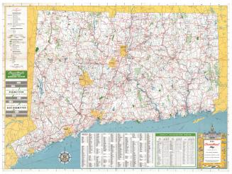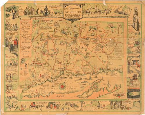
The Commonwealth of Connecticut
DraftsmanDrawn by
Amy Drevenstedt
(American, born 1886)
PublisherPublished by the
Children's Bookshop
Date1926
MediumLithography; colored printer's inks on wove paper
DimensionsPrimary Dimensions (image height x width): 27 5/8 x 34 7/8in. (70.2 x 88.6cm)
Sheet (height x width): 29 1/8 x 36 1/2in. (74 x 92.7cm)
ClassificationsGraphics
Credit LineGift of Lafayette Robinson
Object number1975.105.2
DescriptionMap of Connecticut, using pictures to mark the locations of cities, some historic houses, schools, colleges and universities. Roads are shown in red, railroads in black and rivers in green. Around the borders of the map are vignettes depicting landmarks and scenes from Connecticut's history: the New Haven Green; the Judges' Cave; the Tower of Harkness Memorial Quadrangle; the removal of Yale College from Saybrook; a typical kitchen; a statue of George III that was melted into bullets in Litchfield; the Yale Bowl; Reverend Thomas Hooker's journey from Cambridge to Hartford; the Yankee Peddler; wrestlers settling a boundary dispute between Old Lyme and New London; two natives near a covered bridge; a man from Norwich in a horse and carriage; Putnam's escape from the British; a Litchfield County well; a doorway in Farmington; the home of Roger Sherman; the New London mill; the meeting between Captain Bull and Major Andross; the Charter Oak; Noah Webster holding a dictionary; Webster's home in West Hartford; and Nathan Hale's statue and schoolhouse.
Label TextThe Children's Bookshop of New Haven commissioned the well-known illustrator Amy Drevenstedt to produce this charming pictorial map of Connecticut in 1926. The map includes a great deal of historical trivia about the state calculated to appeal to older children and the general public. The map shows up in booksellers' catalogs fairly frequently, suggesting that a large number of copies were produced and that it sold well. Pictorial maps appear to have been especially popular during the 1930s, when many were produced in conjuction with Connecticut's Tercentenary.
NotesCartographic Note: No scaleStatus
Not on view