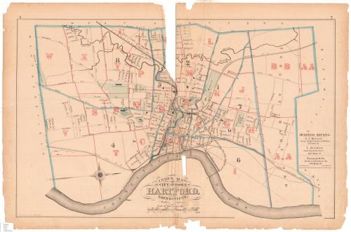
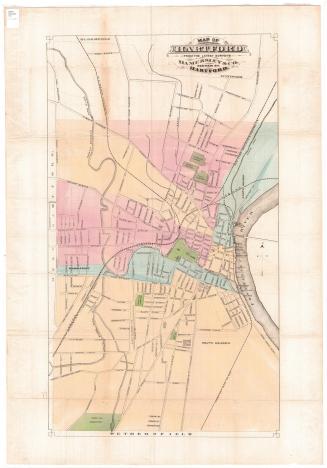
Index Map of the City and Town of Hartford, Connecticut
SurveyorSurveyed by
G. M. Hopkins
(American, active1859 - 1900)
DraftsmanDrawn by
G. M. Hopkins
(American, active1859 - 1900)
PrinterPrinted by
Walter S. MacCormac
(American, active 1874 - 1902)
PublisherPublished by
G. M. Hopkins
(American, active1859 - 1900)
Date1880
MediumLithograph; black printer's ink and watercolor on wove paper
DimensionsPrimary Dimensions (image height x width): 15 1/4 x 24 1/8in. (38.7 x 61.3cm)
Sheet (height x width): 17 3/8 x 26 1/4in. (44.1 x 66.7cm)
ClassificationsGraphics
Credit LineConnecticut Museum of Culture and History collection
Object number2006.133.0
DescriptionMap of the city and town of Hartford, Connecticut, oriented east-west on the map with the Connecticut River at the bottom. The towns of Bloomfield and Windsor form the boundary to the north, the river to the east, Wethersfield (spelled "Weathersfield" on the map) to the south, and West Hartford to the west. The city is divided into sections lettered from A to X, and the town, divided from the city by the city line, is divided into two lettered sections, AA and BB. Local roads are labeled, and cemeteries, hospitals, Trinity College and Bushnell Park are colored green. The Connecticut Valley; New York and New England; and New York, New Haven and Hartford Railroads run through the city and town. On the right side of the map are three business notices, one for S.J. Bestor, Notary Public; I. Altman, realtor; and Fracis & Co., hardware dealers.
Label TextThis Index Map of Hartford, Connecticut must have served as the key to the maps in an 1880 Hartford city atlas.. It shows Hartford in the last quarter of the nineteenth century, when the city was just beginning to expand outwards from its central core and large tracts of undeveloped land still lay surprisingly near the city center. It's not surprising that one of the advertisements on the map is for I. Altman, a real estate broker. William Francis, who appears as one of the principals in Francis & Co., a hardware company featured in another ad, was also a real estate developer, responsible for the development of Parkville and Charter Oak Park in the early 1870s. Both of these areas appear in a rudimentary form on this map.
NotesCartographic Note: Scale: About 1 inch equals 1/4 mileDate Note: The exact date of this map is unknown, but it was probably made after 1878, as that is the year that Trinity College moved from its downtown location to the one shown on the map.
Status
Not on view
Kellogg & Bulkeley
1910-1915