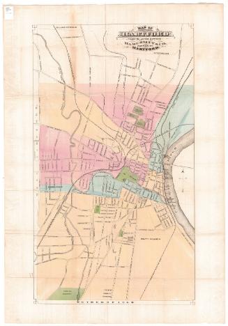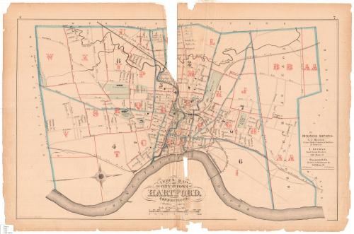
Index Map of the City and Town of Hartford, Connecticut
SurveyorSurveyed by
G. M. Hopkins
(American, active1859 - 1900)
DraftsmanDrawn by
G. M. Hopkins
(American, active1859 - 1900)
PrinterPrinted by
Walter S. MacCormac
(American, active 1874 - 1902)
PublisherPublished by
G. M. Hopkins
(American, active1859 - 1900)
Date1880
MediumLithograph; black printer's ink and watercolor on wove paper
DimensionsPrimary Dimensions (image height x width): 15 1/4 x 24 1/8in. (38.7 x 61.3cm)
Sheet (height x width): 17 3/8 x 26 1/4in. (44.1 x 66.7cm)
Sheet (height x width): 17 3/8 x 26 1/4in. (44.1 x 66.7cm)
ClassificationsGraphics
Credit LineConnecticut Museum of Culture and History collection
DescriptionMap of the city and town of Hartford, Connecticut, oriented east-west on the map with the Connecticut River at the bottom. The towns of Bloomfield and Windsor form the boundary to the north, the river to the east, Wethersfield (spelled "Weathersfield" on the map) to the south, and West Hartford to the west. The city is divided into sections lettered from A to X, and the town, divided from the city by the city line, is divided into two lettered sections, AA and BB. Local roads are labeled, and cemeteries, hospitals, Trinity College and Bushnell Park are colored green. The Connecticut Valley; New York and New England; and New York, New Haven and Hartford Railroads run through the city and town. On the right side of the map are three business notices, one for S.J. Bestor, Notary Public; I. Altman, realtor; and Fracis & Co., hardware dealers.
Object number2006.133.0
NotesCartographic Note: Scale: About 1 inch equals 1/4 mile
Date Note: The exact date of this map is unknown, but it was probably made after 1878, as that is the year that Trinity College moved from its downtown location to the one shown on the map.On View
Not on view