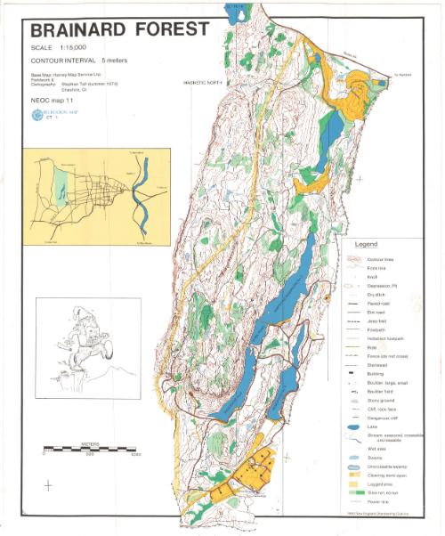
Brainard Forest
MakerCartography by
Stephen Tall
(American)
After a work byAfter a work by the
Harvey Map Service
(British, founded 1978)
PublisherPublished by
New England Orienteering Club
(American, founded 1972)
Date1980
MediumLithography; black and colored printer's inks on wove paper
DimensionsPrimary Dimensions (image height x width): 15 1/8 x 11 1/2in. (38.4 x 29.2cm)
Sheet (height x width): 15 1/8 x 12 1/2in. (38.4 x 31.8cm)
Sheet (height x width): 15 1/8 x 12 1/2in. (38.4 x 31.8cm)
ClassificationsGraphics
Credit LineGift of Ursula Korzenik
DescriptionContour map of Brainard Forest in West Hartford, Connecticut, with Route 44 to the north. Lines and colors are used to denote various land features, including knolls; depressions and pits; dry ditches; roads, trails and paths; fences; stone walls; buildings; boulders; stony ground; cliffs; lakes; streams; swamps; clearing; logged areas; and power lines. Reservoirs 2, 3, and 5 are shown. An inset map on the left shows the greater area. Below this is a sketch of a man wearing a road race number stepping off a cliff as he drops a rolled up piece of paper (presumably a map) behind him.
Object number2004.142.2
NotesCartographic Note: Scale: 1:15,000On View
Not on view