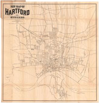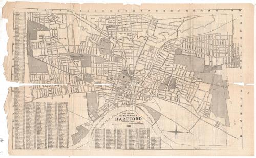

New Map of the City of Hartford, Connecticut
PublisherPublished by
Elihu Geer Sons
(American, founded 1885)
Date1925
MediumLithography; black printer's ink on wove paper
DimensionsPrimary Dimensions (Hartford, image height x width): 15 5/8 x 25 1/4in. (39.7 x 64.1cm)
Sheet (Hartford, height x width): 17 x 27 3/4in. (43.2 x 70.5cm)
Primary Dimensions (West Hartford, image height x width): 14 7/8 x 21 1/2in. (37.8 x 54.6cm)
Sheet (West Hartford, height x width): 17 x 27 3/4in. (43.2 x 70.5cm)
ClassificationsGraphics
Credit LineGift of Dorothy Filley Bidwell
Object number1963.97.1
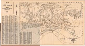
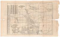
DescriptionMap of Hartford, Connected, oriented east-west on the sheet with the Connecticut River at the bottom. The city is divided into 15 wards. Streets are labeled and parks, hospitals, cemeteries, and colleges are shown. An unnamed railroad line (probably the New York, New Haven and Hartford Railroad) runs through town. The Park River is shown. Broken solid lines run along several streets but are not explained on the map. A street index is printed to the left of and below the map.
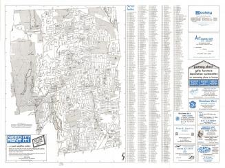
On the back is a map of West Hartford, Connecticut, also oriented east-west on the sheet. Roads are labeled and the American School for the Deaf, Troop B Armory, Elizabeth Park, St. Mary's Home, and the locations of schools are shown. In the lower left corner are four parallel lines that might indicate the presence of railroads. The six reservoirs, Dyke Pond, and unnamed brooks or creeks are depicted. A street index appears to the left of the map.
On the back is a map of West Hartford, Connecticut, also oriented east-west on the sheet. Roads are labeled and the American School for the Deaf, Troop B Armory, Elizabeth Park, St. Mary's Home, and the locations of schools are shown. In the lower left corner are four parallel lines that might indicate the presence of railroads. The six reservoirs, Dyke Pond, and unnamed brooks or creeks are depicted. A street index appears to the left of the map.
Label TextEverything's up to date in Hartford in 1925. The Hartford Electric Light Company Station and the Aviation Field both figure prominently on this map, which shows Hartford as a thriving and bustling city with a booming downtown and a network of trolley lines, bringing commuters in to work in insurance companies, banks, and other businesses from the surrounding suburbs. Shoppers would have found their needs served by several large department stores and many smaller shops. The publishers of the map, Elihu Geer Sons, for many years produced Hartford's city directories. The fold lines in this map suggest that it was removed from one of these directories..
NotesCartographic Note: Scale, Hartford: 1 inch equals 1,323 feet; West Hartford: 1 inch equals 2000 feetStatus
Not on view