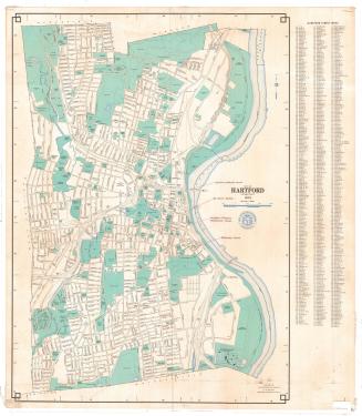
New Map of the City of Hartford, Connecticut
PublisherPublished by
Elihu Geer Sons
(American, founded 1885)
Date1925
MediumLithography; black printer's ink on wove paper
DimensionsPrimary Dimensions (Hartford, image height x width): 15 5/8 x 25 1/4in. (39.7 x 64.1cm)
Sheet (Hartford, height x width): 17 x 27 3/4in. (43.2 x 70.5cm)
Primary Dimensions (West Hartford, image height x width): 14 7/8 x 21 1/2in. (37.8 x 54.6cm)
Sheet (West Hartford, height x width): 17 x 27 3/4in. (43.2 x 70.5cm)
Sheet (Hartford, height x width): 17 x 27 3/4in. (43.2 x 70.5cm)
Primary Dimensions (West Hartford, image height x width): 14 7/8 x 21 1/2in. (37.8 x 54.6cm)
Sheet (West Hartford, height x width): 17 x 27 3/4in. (43.2 x 70.5cm)
ClassificationsGraphics
Credit LineGift of Dorothy Filley Bidwell
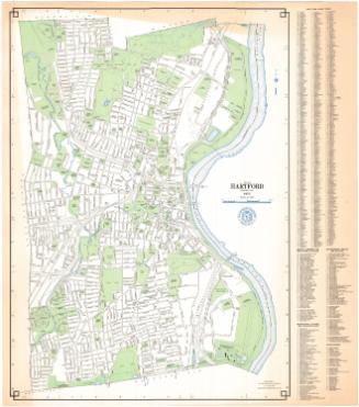
DescriptionMap of Hartford, Connected, oriented east-west on the sheet with the Connecticut River at the bottom. The city is divided into 15 wards. Streets are labeled and parks, hospitals, cemeteries, and colleges are shown. An unnamed railroad line (probably the New York, New Haven and Hartford Railroad) runs through town. The Park River is shown. Broken solid lines run along several streets but are not explained on the map. A street index is printed to the left of and below the map.
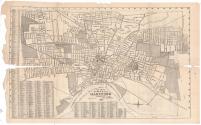
On the back is a map of West Hartford, Connecticut, also oriented east-west on the sheet. Roads are labeled and the American School for the Deaf, Troop B Armory, Elizabeth Park, St. Mary's Home, and the locations of schools are shown. In the lower left corner are four parallel lines that might indicate the presence of railroads. The six reservoirs, Dyke Pond, and unnamed brooks or creeks are depicted. A street index appears to the left of the map.
On the back is a map of West Hartford, Connecticut, also oriented east-west on the sheet. Roads are labeled and the American School for the Deaf, Troop B Armory, Elizabeth Park, St. Mary's Home, and the locations of schools are shown. In the lower left corner are four parallel lines that might indicate the presence of railroads. The six reservoirs, Dyke Pond, and unnamed brooks or creeks are depicted. A street index appears to the left of the map.
Object number1963.97.1
NotesCartographic Note: Scale, Hartford: 1 inch equals 1,323 feet; West Hartford: 1 inch equals 2000 feetOn View
Not on view