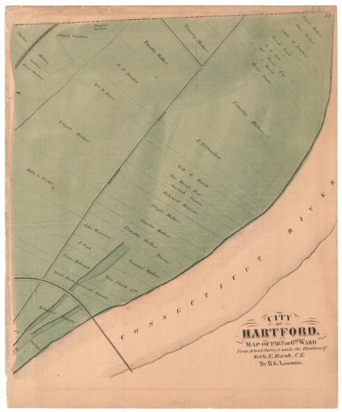
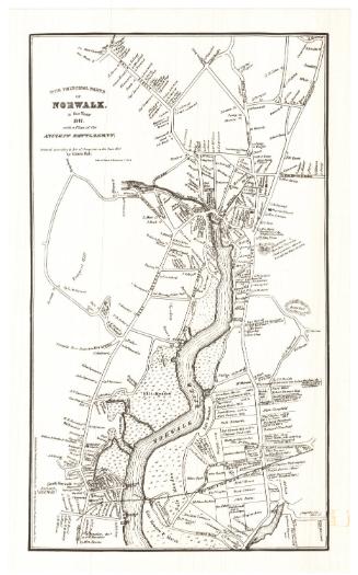
City of Hartford, Map of Part of 6th Ward
MakerMade by
Hiram G. Loomis
(American, 1834 - 1911)
SurveyorSurveyed by
Seth E. Marsh
(American, about 1823 - 1878)
Date1869
MediumLithography; black printer's ink and watercolor on wove paper
DimensionsPrimary Dimensions (image height x width): 15 5/8 x 14 1/4in. (39.7 x 36.2cm)
Sheet (height x width): 17 5/8 x 14 5/8in. (44.8 x 37.1cm)
ClassificationsGraphics
Credit LineConnecticut Museum of Culture and History collection
Object number2006.132.0
DescriptionMap of part of Hartford's Sixth Ward along the Connecticut River, with Meadow Road running parallel to the river. On either side of the road are lots of land, labeled with the owner's name. Two railroad lines are visible at the top and bottom left corners and are unlabeled. On the back of the map is an incomplete Hartford business directory.
Label TextThe long narrow lots that appear on this map were evidently used as pasture for livestock. Two of the major property owners, Timothy Mather and Edward D. Denslow, were respectively a farmer and a cattle dealer. In 1860, an ox belonging to Timothy Mather was killed by lightning during a September storm while "standing in the meadow opposite the railroad," probably in one of the lots shown here. Cattle continued to be raised within the Hartford city limits until after 1900.
NotesCartographic Note: No scaleStatus
Not on view


Silvermine Production
1973