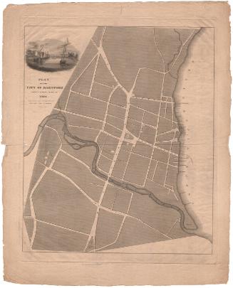
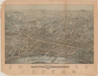
City of Hartford
PublisherPublished by
Isaac Newton Bolles
(American, 1812 - 1864)
Date1840-1850
MediumLithography; black printer's ink and watercolor on wove paper
DimensionsPrimary Dimensions (image height x width): 6 3/4 x 5 5/8in. (17.1 x 14.3cm)
Sheet (height x width): 8 5/16 x 6 3/8in. (21.1 x 16.2cm)
ClassificationsGraphics
Credit LineGift of Alice Welles in memory of her father Edgar T. Welles
Object number1915.7.1
DescriptionMap of the city of Hartford, Connecticut, divided into twelve numbered sections. The streets are all labeled and there are black squares representing the various churches and schools in the city, which are also labeled. The Charter Oak is depicted on Charter Street, east of Main. The Connecticut River and the Little or Mill River (Park River) are the only other natural features depicted.
Label TextCity directories were the nineteenth-century equivalent of the telephone book, a way to find both individuals and businesses in any given city. Maps were a crucial part of such directories, helping users to find their way to the particular address that they were looking for. Isaac Newton Bolles published directories for the city of Hartford, Connecticut between 1842 and 1864. Although Bolles was a letterpress printer and would have printed the text of these books himself, he relied on local lithographers to print the maps which were inserted into them.
NotesCartographic Note: No scaleConstituent Note: Although I. N. Bolles was a printer as well as a publisher, he was a letterpress printer not a lithographer and would have relied on a local lithographic firm for the printing of this map. Since more than one such firm was active in Hartford in the 1840s, it is not clear who printed this map.
Status
Not on view