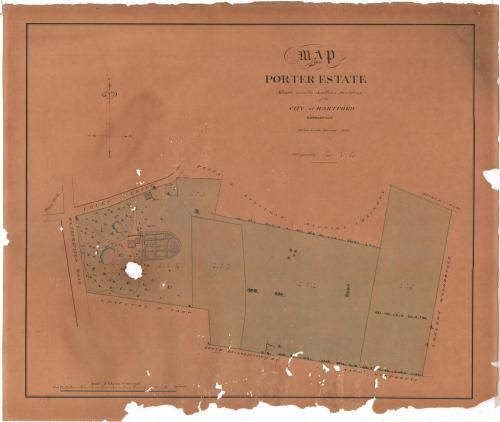
Map of the Porter Estate Situate near the Southern Boundary of the City of Hartford, Connecticut
SurveyorSurveyed by
Marcus Smith
(possibly British, born about 1810)
Date1850
MediumDrawing; black ink and watercolor on wove paper
DimensionsPrimary Dimensions (image height x width): 17 7/8 x 21 1/4in. (45.4 x 54cm)
Sheet (height x width): 20 x 23 1/2in. (50.8 x 59.7cm)
ClassificationsGraphics
Credit LineGift of the Heirs of Morgan B. Brainard
Object number1960.93.23
DescriptionPlat map of Solomon Porter's estate on Wethersfield Road and Coles Street in Hartford, Connecticut. To the north is land owned by Peter D. Stillman, Michael Chauncy and the heirs of J. Russ; to the east is land owned by Sheldon Woodbridge; and to the south is land owned by Nathaniel Humphreys, the South Ecclesiastical Society, and Chauncey W. Camp. The five land lots belonging to Porter are shown with area in acres, rods and perches, and in the first lot, the buildings, formal gardens, paths, ponds and landscape of Porter Place are depicted.
Label TextSolomon Porter was a West Indies trader and wholesale merchant, who about 1850 built a grand Italianate mansion in Hartford, Connecticut, on extensive grounds at the corner of Coles Street and Wethersfield Road opposite South Park. The neighborhood has now totally changed. What was once Coles Street is now part of Wyllys Street, Wethersfield Road is now Wethersfield Avenue, and South Park is known as South Green. Porter's mansion was torn down sometime after 1900. This map thus provides a glimpse of a bit of Hartford's past that is not otherwise well documented.
NotesCartographical Scale: 1 inch equals 2 chainsStatus
Not on view


D. W. Kellogg & Co.
1830-1840