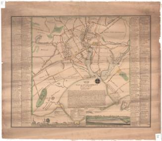
The Principal Parts of Norwalk in the Year 1847 with a Plan of the Ancient Settlement
MakerCompiled by
Edwin Hall
(American, 1802 - 1877)
PrinterPrinted by
Jones & Newman
(American, 1847 - 1849)
Date1847
MediumLithography; black printer's ink and watercolor on wove paper
DimensionsPrimary Dimensions (image height x width): 17 x 9 3/4in. (43.2 x 24.8cm)
Sheet (height x width): 17 7/8 x 11 7/8in. (45.4 x 30.2cm)
ClassificationsGraphics
Credit LineMuseum purchase
Object number2004.141.0
DescriptionMap of the town of Norwalk, Connecticut, from the road to New Canaan to the north, Betts' Hill to the east, a salt meadow and marsh to the south, and Prospect Hill to the west. The Norwalk River runs north-south through the town. The land lots of the "ancient settlement," dating to the mid-1600s, are depicted below a dotted line on the right side of the map. The lines of the old lots are shown and they are labeled with the original owner's name and the current owner's name in parentheses (if known). Many of the roads are labeled and are lined with small open squares that represent dwellings, also labeled. Shaded squares represent churches and a town hall. The New York and New Haven Railroad runs east-west through the town. Natural features depicted include salt meadows and marshes, the river, Betts' Hill and Grumman's Hill.
Label TextEdwin Hall, the pastor of the First Congregational Church in Norwalk, Connecticut, and the author of The Ancient Historical Records of Norwalk (1847), in which this map originally appeared, probably compiled the information in it. Like some other early maps of Connecticut towns, historical data relating to Indian settlements, seventeenth-century homesteads, and Revolutionary War actions is incorporated into a contemporary 1847 map of Norwalk, showing the streets, businesses, and homeowners as of that date. Such maps suggest the way in which an awareness of the past permeated the everyday lives of at least some citizens of nineteenth-century Connecticut.
NotesCartographic Note: No scaleStatus
Not on view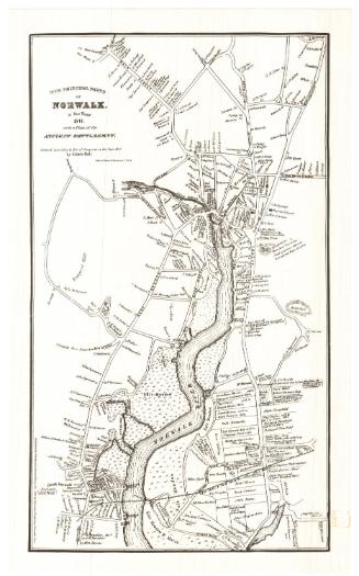
Silvermine Production
1973