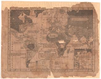
The World
PrinterLithographed by
E.B. & E.C. Kellogg
(American, 1840 - 1867)
PublisherPublished by
Pratt, Woodford & Co.
(American, active 1847 - 1848)
Date1847
MediumLithography; black printer's ink and watercolor on wove paper, lined with paper
DimensionsPrimary Dimensions (image height x width): 27 1/8 x 43 3/8in. (68.9 x 110.2cm)
Sheet (height x width): 28 1/4 x 44 1/2in. (71.8 x 113cm)
Mount (height x width): 28 1/4 x 44 1/2in. (71.8 x 113cm)
ClassificationsGraphics
Credit LineThe Newman S. Hungerford Museum Fund
Object number2010.473.0
DescriptionMap of the world, divided into the Eastern and Western Hemispheres. The continents are shown in different colors, and countries are labeled and divided with broken solid and dotted lines. In between the hemispheres at the bottom of the sheet are two views of the Northern and Southern Hemispheres from the poles. In the corners of the sheet are representations of four peoples: European, represented by Napoleon, "Asiatic," represented by a Chinese man in traditional dress, African, represented by a West African man in a skirt cradling an elephant tusk, and American, represented by Chief Osceola in traditional dress. The cartouche shows three figures with a globe. At the bottom of the sheet are two lists of symbols that appear on Olney's Outline Maps denoting the religions, governments and "states of society" ("savage," "half civilized," "civilized," and "enlightened") of various regions, although this map does not contain any of them.
Label TextJesse Olney was a prominent Connecticut educator, who published many text books, including A Practical System of Modern Geography, Accompanied by a New and Improved Atlas. The first edition of this book appeared in 1828, while Olney was principal of the Stone School in Hartford and it remained a standard text for many years. Olney's Outline Map of the World was printed in Hartford in 1847 and published in New York. It may have been intended to rival Mitchell's Outline Maps, first published in 1839, and also intended for use in school classrooms. Unlike the Mitchell map of the world, Olney's world map shows a portion of the coast of Antarctica.
NotesCartographic Note: No scaleStatus
Not on view