Old Homes and Home Site of Groton, Connecticut
DraftsmanDrawn by
Unknown
Datebefore 1936
MediumLithography; black printer's ink on wove paper
DimensionsPrimary Dimensions (image height x width): 17 x 20 1/4in. (43.2 x 51.4cm)
Sheet (height x width): 17 x 20 1/4in. (43.2 x 51.4cm)
ClassificationsGraphics
Credit LineGift of Mrs. Sylvester Butler
Object number1936.32.1
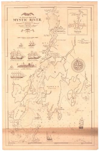
DescriptionMap of the town of Groton, Connecticut, with the Mystic River to the right, the Long Island Sound to the south, and the Thames River to the west, depicting the locations of old homes. Each one is accompanied by a drawing of the building, the owner's name and a date. Roads are depicted but not labeled, and natural features include coves and points along the coast, lakes, islands and brooks.
Label TextOn this rough map, seventeenth and early eighteenth-century houses appear throughout the town of Groton, with clusters in Groton Heights, Center Groton, Old Mystic, West Mystic, Noank, and Poquonnock Bridge. Some of these houses remain standing today; others, such as the Governor Winthrop house on Bluff Point, are long gone. Some house sites are marked only by a tree, presumably because the artist who drew the map knew nothing to suggest what the house might have looked like. The purpose of the map is not clear. It may have been produced in connection with a local history or perhaps a commemoration of the town's founding. The structures are all of course enormously out of scale and suggest a much denser concentration of early houses that may actually have existed in some areas.
NotesCartographic Note: No scaleStatus
Not on view