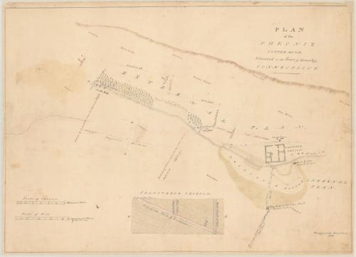


Plan of the Pheonix Copper Mine
SurveyorSurveyed by
Westgarth Forster
(British, 1772 - 1835)
DraftsmanDrawn by
Westgarth Forster
(British, 1772 - 1835)
Date1830
MediumDrawing; black ink and watercolor on paper, lined with paper
DimensionsPrimary Dimensions (image height x width): 20 7/8 x 29 1/2in. (53 x 74.9cm)
Sheet (height x width): 21 1/2 x 29 3/4in. (54.6 x 75.6cm)
Mount (height x width): 21 3/4 x 29 3/4in. (55.2 x 75.6cm)
ClassificationsGraphics
Credit LineGift of C. Russell Noyes
Object number1952.97.2
DescriptionMap of the Phoenix Copper Mine in Granby, Connecticut, showing an external plan, internal plan and transverse section. The external plan is divided into three sections, with the boundary for each one marked with a tree along a line of stakes and stone. The distance between each section is shown in chains and links. At the bottom of the third section on the left is a paling, North Hill and an old shaft; at the bottom of the second section is another old shaft; and at the bottom of the first section is Newgate Prison, Veits' Inn (Viets Inn, most likely), and a third old shaft. Right below, the internal plan shows the location of the mine shaft and well, and gives its depth at 57 feet. The way gate or ladder shaft is located below and to the left of the mine shaft. At the bottom of the sheet is a transverse section of the plan showing the vein, way gate and shaft, and the well shaft.
Label TextCopper had been successfully mined in East Granby, Connecticut during the 1700s. The Phoenix Mine Company hoped to revive these operations in the 1830s, using up-to-date technology and steam engines. This produced the need for an accurate survey. Westgarth Forster, a prominent British mining engineer, surveyed the hillside where the mine was located during a visit in 1830, pinpointing the location of the old mine shafts and providing a transverse section of the strata, based on evidence from the shafts. His map shows old mining activity extending far up the slope from Newgate Prison, which used some of the underground chambers as dungeons during the Revolutionary War and which had remained an active prison as late as 1827.
NotesCartographic note: Scale, external plan, in chains: 1 inch equals 3 chains. Scale, internal plan and transverse section, in feet: 1/2 inch equals 10 feetStatus
Not on view


ca. 1950


David Goodell